Brockley Lane railway station
| Brockley Lane | |
|---|---|
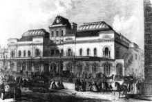
 Site of Brockley Lane station in 1962 | |
| Location | Brockley |
| Local authority | Metropolitan Borough of Lewisham |
| Number of platforms | 2 |
| Railway companies | |
| Original company | London, Chatham and Dover Railway |
| Key dates | |
| June 1872 | Opened |
| 1 January 1917 | Closed to passengers |
| 4 May 1970 | Closed to goods |
| Other information | |
| Lists of stations | |
|
| |
Brockley Lane is a closed railway station in Brockley, south London. It was opened in June 1872 by the London, Chatham and Dover Railway on its Greenwich Park Branch Line. It closed to passengers in January 1917 with the branch, but remained open as a goods station until May 1970 (the Great Northern Railway had constructed a coal depot there in 1883).[1]
The site of the closed station is on Brockley Road, about 140 yards north-east of an open station named Brockley, at a lower level on the London Bridge to Norwood Junction line, crossing under the former Greenwich Park branch. The line through Brockley Lane reopened to freight in 1929 and passengers in 1935 for trains from Dartford to London Victoria via a new link into Lewisham, but there has been no official suggestion that Brockley Lane might be rebuilt.
The entrance to the station was in use as a shop until it was destroyed by fire in 2004. Short sections of the platforms are still visible at the lineside as are traces of the entrances on both sides of the bridge. The former stationmaster's residence opposite is now a private dwelling.
Future
According to the Department for Transport and the Transport for London rail prospectus report released in 2016, it has been listed as one of the Southeastern franchise planned improvements in the document entitled "New interchange at Brockley", suggesting that there might be a case to reopen the station.[2]
References
| Preceding station | Disused railways | Following station | ||
|---|---|---|---|---|
| Nunhead Line closed, station open |
London, Chatham & Dover Railway Greenwich Park Branch Line |
Lewisham Road Line and station closed | ||
Coordinates: 51°27′53″N 0°02′11″W / 51.46472°N 0.03638°W