Broadway Tower, Worcestershire
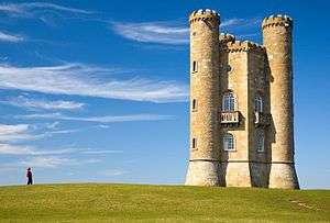
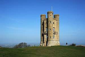
Broadway Tower is a folly on Broadway Hill, near the large village of Broadway, in the English county of Worcestershire,[1] at the second-highest point of the Cotswolds (after Cleeve Hill).[2] Broadway Tower's base is 1,024 feet (312 metres) above sea level.[2] The tower itself stands 65 feet (20 metres) high.[1]
History
The "Saxon" tower was the brainchild of Capability Brown and designed by James Wyatt in 1794[3][4] in the form of a castle, and built for Lady Coventry in 1798–99. The tower was built on a beacon hill, where beacons were lit on special occasions. Lady Coventry wondered whether a beacon on this hill could be seen from her house in Worcester — about 22 miles (35 km) away — and sponsored the construction of the folly to find out. Indeed, the beacon could be seen clearly.
Over the years, the tower was home to the printing press of Sir Thomas Phillipps, and served as a country retreat for artists including William Morris and Edward Burne-Jones who rented it together in the 1880s. William Morris was so inspired by Broadway Tower and other ancient buildings that he founded the Society for the Protection of Ancient Buildings in 1877.
Near the tower is a memorial to the crew of an A.W.38 Whitley bomber that crashed there during a training mission in June 1943.
In the late 1950s, Broadway Tower monitored nuclear fallout in England; an underground Royal Observer Corps bunker was built 50 yards from the Tower. Manned continuously from 1961 and designated as a master post, the bunker was one of the last such Cold War bunkers constructed and, although officially stood down in 1991, the bunker is now one of the few remaining fully equipped facilities in England.
Broadway Tower Country Park
The tower is a tourist attraction and the centre of a country park with various exhibitions open to the public at a fee, as well as a gift shop and restaurant.[1] The place is on the Cotswold Way and can be reached by following the Cotswold Way from the A44 road at Fish Hill, or by a steep climb out of Broadway village. The A44 is a major road in the United Kingdom that runs from Oxford in southern England to Aberystwyth in West Wales.
References
| Wikimedia Commons has media related to Broadway Tower. |
- 1 2 3 "Broadway Tower Country Park". Broadway Cotswolds. Retrieved 16 June 2018.
- 1 2 "Welcome to Broadway Tower". Broadway Tower: Cotswold Highest Castle. Retrieved 16 June 2018.
- ↑ "History of Broadway Tower". Visit Broadway. January 2, 2016. Retrieved 16 June 2018.
- ↑ Dated drawings in the estate office at Croome Court, noted by Howard Colvin, A Biographical Dictionary of British Architects 1600-1840, 3rd ed. (Yale University Press) 1995.