Britannia Depicta
.jpg)
Britannia Depicta was an illustrated road atlas for Britain. It was printed in numerous editions over many decades from 1720 into the 19th century and updated with engravings by many artisans who worked from drawings of other artists. It featured strip maps.[1]
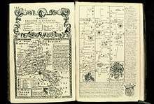
The atlas was based on the earlier work of John Ogilby who published the first British road atlas in 1675. Britannia Depicta was printed in 1720 by Emanuel Bowen and John Owen's firm Bowen & Owen. It was one of Bowen's earliest works.
A road atlas, it contains two hundred and seventy three road maps along with drawings of landmarks and miniature county maps[2] of each of the counties of England and Wales. It followed on John Ogilby's original with updated style of historical and heraldic detail. It was an unusual feature of the atlas that the maps were engraved on both sides of each page, and this resulted in a handier-sized book.
Cadell & Davies editions

Cadell & Davies published its own editions of the Britannia Depicta atlas over many years, with accompanying descriptions by Samuel Lysons.[3] Engraved plates for their Britannia Depicta are dated 1803–1818.[3]
The Quarterly Review of 1816 reported it was ordered along with Magna Britannia.[4]
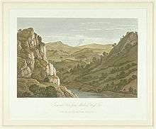
Landscapes by Joseph Farington were included in Cadell and Davies' six-volume "modernisation" of the illustrated atlas. His contributions include topographical Views in Cornwall (1814) and other views. He also depicted Devon for a 7th edition and had his drawings engraved but they were never published.
Engravers
Engravers who worked on the Cadell & Davies editions include:
- William Byrne (engraver)
- William Angus (engraver) 1752–1821
- M. S. Barenger
- John Byrne (engraver), 1786–1847
- Letitia Byrne 1779–1849
- William Byrne (engraver) 1743–1805
- George Cooke (engraver) 1781–1834
- Frederick Rudolph Hay 1784–?
- John Landseer 1769–1852
- Samuel Middiman ca. 1750–1831
- James Neagle 1760?–1822
- Charles Pye (engraver) 1777–1864
- John Pye 1782–1874
- John Scott (engraver) 1774–1827
- Thomas Woolnoth, 1785–1857
- William Woolnoth 1780–1837
Illustrators
Illustrations in the Cadell & Davies editions were made by artists including:
- William Alexander 1767–1816
- John Byrne 1786–1847
- Joseph Farington 1747–1821
- Thomas Hearne 1744–1817
- Frederick Nash 1782–1856
- John Powell, 1780-ca. 1833
- Robert Smirke 1752–1845
- John Smith (perhaps John Raphael Smith?)
- William Turner
- J. M. W. Turner (Joseph Mallord William), 1775–1851
- John Varley 1778–1842
- Thomas Webster 1800–1886
References
- ↑ https://books.google.com/books?id=UKk1AQAAMAAJ&pg=RA1-PA51&dq=Britannia+Depicta&hl=en&sa=X&ved=0ahUKEwikpdqn4-3bAhUPiqwKHbxVACc4HhDoAQhPMAc#v=onepage&q=Britannia%20Depicta&f=false
- ↑ http://www.thejournal.co.uk/news/north-east-news/300-year-old-britannia-depicta-atlas-found-4400801
- 1 2 Maj, Yale Center for British Art, Lec. "Britannia depicta :". collections.britishart.yale.edu.
- ↑ https://books.google.com/books?id=XrNZAAAAcAAJ&pg=RA2-PA7&dq=Britannia+Depicta&hl=en&sa=X&ved=0ahUKEwiF55j84e3bAhVFX60KHU3gBUo4FBDoAQgoMAA#v=onepage&q=Britannia%20Depicta&f=false