Brisk Island
| Native name: Culgarool | |
|---|---|
 Brisk Island and surrounds | |
| Geography | |
| Location | Northern Australia |
| Coordinates | 18°47′02″S 146°32′31″E / 18.784°S 146.542°ECoordinates: 18°47′02″S 146°32′31″E / 18.784°S 146.542°E |
| Archipelago | Great Palm Island group |
| Area | 0.51 km2 (0.20 sq mi) |
| Administration | |
| State | Queensland |
| LGA | Palm Island Aboriginal Shire Council |
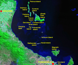
Brisk Island is an island in the Great Palm Island group. The nearest island is Great Palm Island, after which the group is named. The Aboriginal name for Brisk Island is Culgarool Island.[1]
The island is situated in Steamer Passage, Halifax Bay approximately 2 kilometres (1.2 mi) southwest of Palm Island in Queensland, Australia. It is around 51 hectares or 0.51 square km in size.[2]
See also
References
- ↑ "Indigenous Land Use Agreement: QI2003/052 Coolagree Sponge Farm ILUA". National Native Title Tribunal. Retrieved 2011-01-03.
- ↑ "Map of Brisk Island (Culgarool), QLD".
This article is issued from
Wikipedia.
The text is licensed under Creative Commons - Attribution - Sharealike.
Additional terms may apply for the media files.