Brentwood Town Centre station
Brentwood Town Centre | |||||||||||
|---|---|---|---|---|---|---|---|---|---|---|---|
| SkyTrain station | |||||||||||
 | |||||||||||
| Location | 4533 Lougheed Highway, Burnaby | ||||||||||
| Coordinates | 49°15′59″N 123°00′06″W / 49.26633°N 123.00163°WCoordinates: 49°15′59″N 123°00′06″W / 49.26633°N 123.00163°W | ||||||||||
| Owned by | BC Ministry of Transportation, TransLink | ||||||||||
| Platforms | Side platforms | ||||||||||
| Tracks | 2 | ||||||||||
| Construction | |||||||||||
| Structure type | Elevated | ||||||||||
| Disabled access | Yes | ||||||||||
| Other information | |||||||||||
| Station code | BR | ||||||||||
| Fare zone | 2 | ||||||||||
| History | |||||||||||
| Opened | August 31, 2002 | ||||||||||
| Traffic | |||||||||||
| Passengers (2017[1]) | 5,500 | ||||||||||
| Services | |||||||||||
| |||||||||||
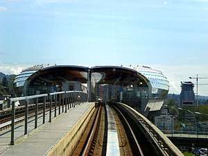
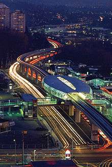
Brentwood Town Centre (sometimes abbreviated as Brentwood) is an elevated station on the Millennium Line of Metro Vancouver's SkyTrain rapid transit system. The station is located above Lougheed Highway east of Willingdon Avenue in Burnaby, British Columbia. The station is adjacent to the Brentwood Town Centre mall, a mid-size shopping centre.
Structure and design
Brentwood Town Centre station is the only station in the system that is built on a median, with the entire station footprint located directly above a roadway. The station is also designed to serve as a pedestrian overpass across Lougheed Highway, which requires the station platforms to be high above the roadway and a mezzanine/concourse to be built below the platform level. Only two other Millennium Line station have this feature (Lougheed Town Centre station and Gilmore station).
The station is built using a combination of wood and steel, customly designed to provide a curved appearance. The extensive use of glass for the outer wall make the station glow at night.
On May 11, 2002, Perkins+Will Canada, designers of the station, were honoured for their work with a Governor General's Medal in Architecture.[2]
Station information
Station layout
| T | Side platform; Doors will open on the right | |
| Platform 1 Inbound |
← ■ Millennium Line towards VCC–Clark (Gilmore) | |
| Platform 2 Outbound |
■ Millennium Line towards Lafarge Lake–Douglas (Holdom) → | |
| Side platform; Doors will open on the right | ||
| C | Concourse Level | Connects to north and south ends of Lougheed Highway Fare gates, Compass Ticket vending machines |
| S | Street Level | Entrance/Exit |
Entrances
North Entrance ![]()
North Entrance Mall/Bus Loop Access ![]()
South Entrance: Stair-only access connecting the station concourse with the sidewalk on the south side of Lougheed Highway. This entrance provides an alternate connection to various bus routes in the area.
Transit connections
Brentwood Tow Centre station is a major regional connection point for bus routes serving north Burnarby, Metrotown, North Vancouver and New Westminster. It is also has a connection to the British Columbia Institute of Technology (BCIT).
Bus bay assignments are temporary as of August 2014. Bus bay assignments are as follows:[3]
| Bay | Location | Routes |
|---|---|---|
| 1 | Willingdon Avenue Northbound |
130 To Hastings / Phibbs Exchange / Capilano University 134 Lake City Station |
| 2 | Lougheed Highway Westbound |
134 Lake City Station N9 Downtown |
| 3 | Lougheed Highway Eastbound |
136 Lougheed Station |
| 4 | Lougheed Highway Eastbound |
123 New Westminster Station |
| 5 | Lougheed Highway Eastbound |
25 UBC N9 Coquitlam Station |
| 6 | Willingdon Avenue Southbound |
130 Metrotown Station |
| 7 | Willingdon Avenue Southbound |
134 Brentwood Station |
References
- ↑ "2017 Transit Service Performance Review" (PDF). translink.ca. TransLink. Retrieved June 28, 2018.
- ↑ "Perkins + Will Canada: Awards".
- ↑ Map of Brentwood Town Centre Station
External links
![]()
| |||||||||||||
| |||||||||||||
| |||||||||||||