Breitenauriegel
| Breitenauriegel | |
|---|---|
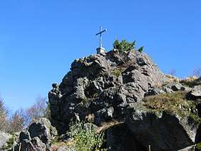 The summit of the Breitenauriegel | |
| Highest point | |
| Elevation | 1,116 m above sea level (NN) (3,661 ft) |
| Coordinates | 48°54′23″N 13°01′48″E / 48.90643°N 13.03005°ECoordinates: 48°54′23″N 13°01′48″E / 48.90643°N 13.03005°E |
| Geography | |
 Breitenauriegel | |
| Parent range | Bavarian Forest |
| Geology | |
| Type of rock | gneiss |
The Breitenauriegel (colloquially also called the Breitenauer Riegel) is a mountain in the Bavarian Forest of Germany.
The mountain is 1,116 m above sea level (NHN)[1] high and rises from the crest of the Vorderer Bavarian Forest near Bischofsmais and the neighbouring summits of the Geißkopf and the Dreitannenriegel.
At the top is a summit rock with a summit cross and view looking northwest towards Gotteszell. North of the Breitenauriegel, towards, Geißkopf, is the plateau of Oberbreitenau. Various footpaths from Habischried, Bischofsmais, Rusel and Rohrmünz, including the Main-Danube Way with the Ostlinie[1] make their way to the summit. About 750 metres southeast of the top is a works hut for the Deggendorf branch of the mountain rescue service, the Bergwacht.[2][1]
The peak and most of the mountainsides are in the Special Area of Conservation called the Deggendorfer Vorwald.[3]
References
External links
| Wikimedia Commons has media related to Breitenauriegel. |