Breich railway station
| Breich | |
|---|---|
| Scottish Gaelic: Brìch[1] | |
 | |
| Location | |
| Place | Breich |
| Local authority | West Lothian |
| Coordinates | 55°49′39″N 3°40′03″W / 55.8275°N 3.6675°WCoordinates: 55°49′39″N 3°40′03″W / 55.8275°N 3.6675°W |
| Grid reference | NS956606 |
| Operations | |
| Station code | BRC |
| Managed by | Abellio ScotRail |
| Number of platforms | 2 |
|
Live arrivals/departures, station information and onward connections from National Rail Enquiries | |
| Annual rail passenger usage* | |
| 2012/13 |
|
| 2013/14 |
|
| 2014/15 |
|
| 2015/16 |
|
| 2016/17 |
|
| History | |
| 9 July 1869 | Opened[2] |
| National Rail – UK railway stations | |
| * Annual estimated passenger usage based on sales of tickets in stated financial year(s) which end or originate at Breich from Office of Rail and Road statistics. Methodology may vary year on year. | |
|
| |
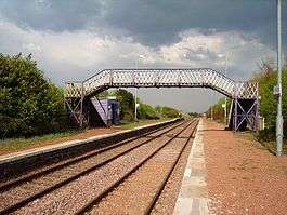
Breich railway station is a rural railway station serving the village of Breich in West Lothian, Scotland. It is located on the Shotts Line, 21 miles (34 km) west of Edinburgh Waverley towards Glasgow Central. It is currently the sixth-least-used station in the UK and the second-least-used in Scotland, after Barry Links.[3]
History
The station was opened by the Caledonian Railway on their Cleland and Midcalder Line on 9 July 1869.[2] Breich is named after the nearby Breich Water.[4] The station pre-dates the present-day (2015) village of Breich and OS maps show that it has never possessed freight facilities such as loading docks and sidings, etc.[4]
The area although now very rural was once highly industrialised with several collieries, lime works, iron workings, etc. nearby, together with the Levenseat Branch of the North British Railway and the originally 4ft 6in Scotch gauge Wilsontown, Morningside and Coltness line with its old terminus station of Longridge[4] opened in 1845 and closed in 1848.[5]
A ticket office and waiting room was still present in 1962 as shown by the photograph of that date, together with a linesman's brick hut building, both on the Glasgow bound platform.
The final section of the platforms running towards Edinburgh are slightly higher, have larger edging stones and a different construction suggesting that they were built at a different date than the rest of the platforms.
The station gardens have an unusual diversity of planted shrubs and trees.

Services
| Preceding station | Following station | |||
|---|---|---|---|---|
| Addiewell | Abellio ScotRail Shotts Line |
Fauldhouse | ||
| Historical railways | ||||
| Addiewell Line and station closed |
Caledonian Railway Cleland and Midcalder Line |
Fauldhouse | ||
| Newpark Loop line and station closed |
Caledonian Railway Cleland and Midcalder Line Addiewell Loop |
|||
2011
Mondays to Saturdays saw one train to Edinburgh and two towards Glasgow Central with no Sunday service.
2016
Monday to Saturdays the station is served by one eastbound towards Edinburgh and one westbound train towards Glasgow Central per day. There is no Sunday service.[6]
Station usage
In 2014–15, Breich was the tenth least-used station in Britain, with 92 passenger exits and entries.[7]
West Lothian Council's Route Utilisation Strategy suggests that if there was an increase in service frequency on the Shotts Line more services could stop at Breich. This could help future developments in the Breich and Longridge areas.[8]
Proposed closure
On 21 June 2017, Network Rail announced that they had begun consultation on the proposed closure of the station due to low patronage and if retained will avoid heavy expenditure to update the station prior to electrification of the line.[9][10] It would have been the first station in Scotland to close in over 30 years.[10]
The overwhelming response to the consultation was in favour of keeping Breich station open. Many respondents wished to see more services calling at Breich Station to increase patronage. It has been confirmed that the station will remain open and plans are being developed to possibly improve services.[11]
It has been confirmed that the station will temporarily close from 23 June 2018 for 12 weeks while the station is redeveloped as part of a £2.4 million project to make it suitable for the new electric trains that will use the route. The redevelopment will include work to the platforms in order to make them compliant in both height and length for the new services as well as ensuring both platforms have ramped access. Work will also be undertaken to station facilities such as waiting shelters, CCTV, etc.[12][13]
References
Notes
- ↑ Brailsford 2017, Gaelic/English Station Index.
- 1 2 Butt (1995), page 43
- ↑ http://orr.gov.uk/__data/assets/excel_doc/0018/15363/station-usage-2013-14-data.xls
- 1 2 3 "View: Linlithgowshire Sheet XII.SW (includes: West Calder; Whitburn) - Ordnance Survey Six-inch 2nd and later editions, Scotland, 1892-1960". maps.NLS.uk. Retrieved 6 December 2017.
- ↑ Butt (1995), page 149
- ↑ Table 224 National Rail timetable, May 2016
- ↑ "Revealed: Britain's busiest and quietest stations". BBC News. 15 December 2015.
- ↑ "Network Rail - resource not found" (PDF). www.NetworkRail.co.uk. Retrieved 6 December 2017.
- ↑ "Breich station: proposed closure – public consultation – Network Rail". www.NetworkRail.co.uk. Retrieved 6 December 2017.
- 1 2 "Station with three passengers faces closure". BBC News. BBC. 22 June 2017. Retrieved 22 June 2017.
- ↑ "Transport User Voice – What's happening in Scotland? - Transport Focus". TransportFocus.org.uk. Retrieved 6 December 2017.
- ↑ https://www.networkrailmediacentre.co.uk/news/breich-station-closure-is-platform-for-gbp-2-4m-redevelopment#
- ↑ http://www.railwaygazette.com/news/single-view/view/uk-railway-news-round-up-68.html
Sources
- Brailsford, Martyn, ed. (December 2017) [1987]. Railway Track Diagrams 1: Scotland & Isle of Man (6th ed.). Frome: Trackmaps. ISBN 978-0-9549866-9-8.
- Butt, R. V. J. (1995). The Directory of Railway Stations: details every public and private passenger station, halt, platform and stopping place, past and present (1st ed.). Sparkford: Patrick Stephens Ltd. ISBN 978-1-85260-508-7. OCLC 60251199.
- Jowett, Alan (March 1989). Jowett's Railway Atlas of Great Britain and Ireland: From Pre-Grouping to the Present Day (1st ed.). Sparkford: Patrick Stephens Ltd. ISBN 978-1-85260-086-0. OCLC 22311137.
- Jowett, Alan (2000). Jowett's Nationalised Railway Atlas (1st ed.). Penryn, Cornwall: Atlantic Transport Publishers. ISBN 978-0-906899-99-1. OCLC 228266687.
- Yonge, John (May 1987). Gerald Jacobs, ed. British Rail Track Diagams - Book 1: ScotRail (1st ed.). Exeter: Quail Map Company. ISBN 0-9006-0948-6.
- Yonge, John (February 1993). Gerald Jacobs, ed. Railway Track Diagams - Book 1: Scotland and the Isle of Man (2nd ed.). Exeter: Quail Map Company. ISBN 0-9006-0995-8.
- Yonge, John (April 1996). Gerald Jacobs, ed. Railway Track Diagams - Book 1: Scotland and the Isle of Man (3rd ed.). Exeter: Quail Map Company. ISBN 1-8983-1919-7.
- Yonge, John (2007). Gerald Jacobs, ed. Railway Track Diagams - Book 1: Scotland & Isle of Man (Quail Track Plans) (fifth ed.). Bradford on Avon: Trackmaps (formerly Quail Map Co). ISBN 978-0-9549866-3-6. OCLC 79435248.
External links
| Wikimedia Commons has media related to Breich railway station. |