Branchton railway station
| Branchton | |
|---|---|
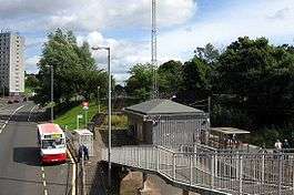 View looking towards Greenock from footbridge over Inverkip Road | |
| Location | |
| Place | Branchton |
| Local authority | Inverclyde |
| Coordinates | 55°56′25″N 4°48′15″W / 55.9404°N 4.8042°WCoordinates: 55°56′25″N 4°48′15″W / 55.9404°N 4.8042°W |
| Grid reference | NS250754 |
| Operations | |
| Station code | BCN |
| Managed by | Abellio ScotRail |
| Number of platforms | 1 |
|
Live arrivals/departures, station information and onward connections from National Rail Enquiries | |
| Annual rail passenger usage* | |
| 2012/13 |
|
| 2013/14 |
|
| 2014/15 |
|
| 2015/16 |
|
| 2016/17 |
|
| History | |
| Original company | BR Scottish Region |
| 5 June 1967 | Opened |
| National Rail – UK railway stations | |
| * Annual estimated passenger usage based on sales of tickets in stated financial year(s) which end or originate at Branchton from Office of Rail and Road statistics. Methodology may vary year on year. | |
|
| |
Branchton railway station is a railway station in Scotland opened in 1967 under British Rail located in the south-west of the town of Greenock, beside the area called Branchton. The station is on the Inverclyde Line, 24¾ miles (40 km) west of Glasgow Central. The station is managed by Abellio ScotRail.
Services
There is an hourly service daily (including Sundays) eastbound to Paisley Gilmour Street & Glasgow Central and westbound to Wemyss Bay.[1]
| Preceding station | Following station | |||
|---|---|---|---|---|
| IBM | Abellio ScotRail Inverclyde Line |
Drumfrochar | ||
Gallery
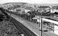 The station in 1974
.jpg) The station building had been un-manned and boarded up for several years. It was boarded up shortly after being completely renovated, The station Building was demolished in March 2015. Inverkip Road is to the left; Ravenscraig Court is obscured by the trees.
The station building had been un-manned and boarded up for several years. It was boarded up shortly after being completely renovated, The station Building was demolished in March 2015. Inverkip Road is to the left; Ravenscraig Court is obscured by the trees.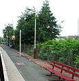 Looking down the platform, away from the station building. The posts with the yellow bands are for new CCTV equipment for use by train drivers.
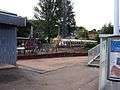 Eastbound Class 334 train arriving at the station
Notes
- ↑ Table 219 National Rail timetable, May 2016
References
- Butt, R. V. J. (1995). The Directory of Railway Stations: details every public and private passenger station, halt, platform and stopping place, past and present (1st ed.). Sparkford: Patrick Stephens Ltd. ISBN 978-1-85260-508-7. OCLC 60251199.
- Jowett, Alan (March 1989). Jowett's Railway Atlas of Great Britain and Ireland: From Pre-Grouping to the Present Day (1st ed.). Sparkford: Patrick Stephens Ltd. ISBN 978-1-85260-086-0. OCLC 22311137.
- Yonge, John (May 1987). Gerald Jacobs, ed. British Rail Track Diagams - Book 1: ScotRail (1st ed.). Exeter: Quail Map Company. ISBN 0-9006-0948-6.
- Yonge, John (February 1993). Gerald Jacobs, ed. Railway Track Diagams - Book 1: Scotland and the Isle of Man (2nd ed.). Exeter: Quail Map Company. ISBN 0-9006-0995-8.
- Yonge, John (April 1996). Gerald Jacobs, ed. Railway Track Diagams - Book 1: Scotland and the Isle of Man (3rd ed.). Exeter: Quail Map Company. ISBN 1-8983-1919-7.
- Yonge, John (2007). Gerald Jacobs, ed. Railway Track Diagams - Book 1: Scotland & Isle of Man (Quail Track Plans) (fifth ed.). Bradford on Avon: Trackmaps (formerly Quail Map Co). ISBN 978-0-9549866-3-6. OCLC 79435248.
This article is issued from
Wikipedia.
The text is licensed under Creative Commons - Attribution - Sharealike.
Additional terms may apply for the media files.