Brampton Township, Sargent County, North Dakota
| Brampton Township, North Dakota | |
|---|---|
| Township | |
 Brampton Township, North Dakota Location within the state of North Dakota | |
| Coordinates: 45°58′44″N 97°48′37″W / 45.97889°N 97.81028°WCoordinates: 45°58′44″N 97°48′37″W / 45.97889°N 97.81028°W | |
| Country | United States |
| State | North Dakota |
| County | Sargent |
| Area | |
| • Total | 36.3 sq mi (94.0 km2) |
| • Land | 36.3 sq mi (93.9 km2) |
| • Water | 0.1 sq mi (0.1 km2) |
| Elevation | 1,306 ft (398 m) |
| Population (2000) | |
| • Total | 66 |
| • Density | 1.8/sq mi (0.7/km2) |
| Time zone | UTC-6 (Central (CST)) |
| • Summer (DST) | UTC-5 (CDT) |
| ZIP code | 58017 |
| Area code(s) | 701 |
| FIPS code | 38-08980[1] |
| GNIS feature ID | 1036788[2] |
Brampton Township is a civil township in Sargent County, North Dakota, United States.
Brampton Cemetery is outside city limits.
Of the Township's 66 residents, 61 are white, four are Native, and one is "two or more races".
References
- ↑ "American FactFinder". United States Census Bureau. Archived from the original on 2013-09-11. Retrieved 2008-01-31.
- ↑ "US Board on Geographic Names". United States Geological Survey. 2007-10-25. Retrieved 2008-01-31.
External links
Municipalities and communities of Sargent County, North Dakota, United States | ||
|---|---|---|
| Cities | 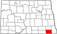 | |
| Townships | ||
| CDP | ||
| Unincorporated community |
| |
| Indian reservations | ||
| Footnotes | ‡This populated place also has portions in an adjacent county or counties | |
This article is issued from
Wikipedia.
The text is licensed under Creative Commons - Attribution - Sharealike.
Additional terms may apply for the media files.