River Bradford
| River Bradford | |
|---|---|
 Bradford Dale | |
| Country | England |
| Physical characteristics | |
| Main source | Gratton Moor |
| River mouth | River Lathkill |
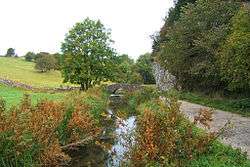
The River Bradford is a river in the Peak District National Park in Derbyshire. Its source is on Gratton Moor and after passing below Youlgreave it joins the River Lathkill at Alport.[1] Less than 4 miles (7 km) in length,[2] its waters are very clear due to the limestone rock over which it flows, and its width has been enhanced by a number of weirs which also encourage white-throated dippers to breed in the ponds created. The river is owned and managed by the Haddon Estate and is home to brown trout and white-clawed crayfish.[3] The valley is known as Bradford Dale, and the Limestone Way passes through it.[4]
See also
References
- ↑ "Bradford River Action Group - Bradford Dale". www.riverintime.org.uk. Retrieved 23 February 2018.
- ↑ "Bradford Catchment (trib of Lathkill)". environment.data.gov.uk. Retrieved 23 February 2018.
- ↑ "Monitoring the level of the River Bradford - Technolog". technolog.com. Retrieved 23 February 2018.
- ↑ DerbyshireUK.net accessed 16 May 2008
| Unitary authorities | |
|---|---|
| Boroughs or districts | |
| Major settlements |
|
| Rivers | |
| Topics | |
Coordinates: 53°10′36″N 1°40′20″W / 53.17670°N 1.67220°W
This article is issued from
Wikipedia.
The text is licensed under Creative Commons - Attribution - Sharealike.
Additional terms may apply for the media files.