Boysen State Park
| Boysen State Park | |
| Wyoming State Park | |
 Boysen Reservoir | |
| Country | |
|---|---|
| State | |
| County | Fremont |
| Elevation | 4,731 ft (1,442 m) [1] |
| Coordinates | 43°25′01″N 108°10′37″W / 43.417°N 108.177°WCoordinates: 43°25′01″N 108°10′37″W / 43.417°N 108.177°W [1] |
| Total area | 35,952 acres (14,549 ha) [2] |
| - Land | 16,788 acres (6,794 ha) |
| - Water | 19,164 acres (7,755 ha) |
| Established | 1956 |
| Management | Wyoming Division of State Parks and Historic Sites |
 Location in Wyoming | |
| Website: Boysen State Park | |
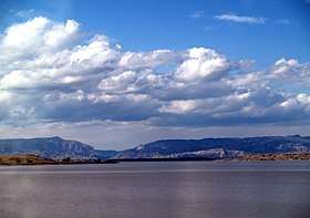
Boysen State Park is a public recreation area surrounding the Boysen Reservoir, an impoundment of the north-flowing Wind River, in Fremont County, Wyoming. The state park covers more than 35,000 acres (14,000 ha) at the south end of the Owl Creek Mountains at the mouth of the Wind River Canyon.[3]
History
The park was established in 1956 following completion of the Boysen Dam in 1951. It is named for Asmus Boysen, who built the site's first dam in 1908. Part of the original dam can still be seen.[4]
Activities and amenities
The park offers multiple campgrounds, boat launches, and a privately operated marina.[3] Game fish found in the reservoir include walleye, sauger, perch, crappie, ling, rainbow, cutthroat, and brown trout.[4]
References
- 1 2 "Boysen Dam". Geographic Names Information System. United States Geological Survey.
- ↑ "Table 1. Facilities managed by Wyoming State Parks, Historic Sites and Trails" (PDF). SOAR 2021. Wyoming Department of State Parks and Cultural Resources. p. 12. Retrieved March 15, 2017.
- 1 2 "Boysen State Park". Wyoming State Parks, Historic Sites & Trails. State of Wyoming. Retrieved August 21, 2017.
- 1 2 "Boysen State Park Brochure" (PDF). Wyoming Division of State Parks and Historic Sites. Retrieved March 15, 2017.
External links
- Boysen State Park Wyoming State Parks, Historic Sites & Trails
- Boysen State Park Brochure Wyoming Division of State Parks and Historic Sites
| Wikimedia Commons has media related to Boysen State Park. |
This article is issued from
Wikipedia.
The text is licensed under Creative Commons - Attribution - Sharealike.
Additional terms may apply for the media files.