Boyoma Falls
| Boyoma Falls | |
|---|---|
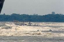
.jpg) Seventh cataract of Boyoma/Stanley Falls near Kisangani | |
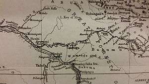
| Location | Lualaba River, Kisangani, Democratic Republic of the Congo |
| Type | Cataract |
| Total height | 200 feet (61 m) |
| Average width | 4,500 feet (1,400 m) |
| Watercourse | Congo River |
| Average flow rate | 17,000 m3/s (600,000 cu ft/s) |
Boyoma Falls, formerly known as Stanley Falls, consists of seven cataracts, each no more than 5 m (16 ft) high, extending over more than 100 km (62 mi) along a curve of the Lualaba River between the river port towns of Ubundu and Kisangani/Boyoma in the Orientale Province of the Democratic Republic of the Congo.[1]:Vol.Two,175
At the bottom of the rapids, the Lualaba becomes the Congo River. The seven cataracts have a total drop of 61 m (200 ft). The two major cataracts are the first below Ubundu, forming a narrow and crooked stream that is hardly accessible, and the last that can easily be seen and also be visited from Kisangani.
A 1m-gauge portage railway bypasses the series of rapids, connecting Kisangani and Ubundu.
Boyoma Falls is the largest waterfall by volume of annual flow rate in the world.
Especially among French speakers the cataracts are also known as Wagenia Falls (chutes Wagenia), referring to the local people of fishermen named Wagenia or Wagenya who have developed a special technique to fish in the river. They build systems of wooden tripods across the rapids fixed in holes carved in the rock by the water current. They serve as anchors for baskets that entrap large fish.
According to Stanley, "...by taking advantage of the rocks, the natives have been enabled to fix upright heavy poles, 6 inches in diameter, to each of which they attach enormous fish-baskets by means of rattan-cane cable. There are probably sixty or seventy baskets laid in the river on each side, every day; and though some may be brought up empty, in general they seem to be tolerably successful, for out of half-a-dozen baskets...twenty-eight large fish were collected..."[1]:197

References
External links
| Wikimedia Commons has media related to Boyoma Falls. |