Bowles West Peak
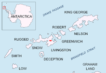


Bowles West Peak (Vrah Zapaden Bowles \'vr&h 'za-pa-den 'bOls\) is a peak rising to 678 m at the western extremity of Bowles Ridge in eastern Livingston Island in Antarctica. The peak has precipitous and partly ice free western slopes and overlooks Perunika Glacier to the southwest.
The feature takes its name from Mount Bowles, the summit of the eponymous ridge.
Location
The peak is located at 62°36′47.5″S 60°13′13″W / 62.613194°S 60.22028°WCoordinates: 62°36′47.5″S 60°13′13″W / 62.613194°S 60.22028°W which is 1 km west by north of Mount Bowles (822 m), 790 m south by east of Hemus Peak, 6.24 km east of Aleko Rock and 3.2 km east by northeast of Rezen Knoll.
The peak was roughly mapped by the British in 1968 and the Spanish in 1991. The peak was mapped by Bulgaria from a 1995-96 topographic survey.
Maps
- L.L. Ivanov et al. Antarctica: Livingston Island and Greenwich Island, South Shetland Islands. Scale 1:100000 topographic map. Sofia: Antarctic Place-names Commission of Bulgaria, 2005.
- L.L. Ivanov. Antarctica: Livingston Island and Greenwich, Robert, Snow and Smith Islands. Scale 1:120000 topographic map. Troyan: Manfred Wörner Foundation, 2009.
References
- Bowles West Peak. SCAR Composite Gazetteer of Antarctica
- Bulgarian Antarctic Gazetteer. Antarctic Place-names Commission. (details in Bulgarian, basic data in English)
This article includes information from the Antarctic Place-names Commission of Bulgaria which is used with permission.