Boustead station (PAAC)
Boustead | ||||||||||||||||||||
|---|---|---|---|---|---|---|---|---|---|---|---|---|---|---|---|---|---|---|---|---|
|
| ||||||||||||||||||||
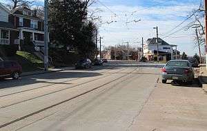 The station area in 2017. Nothing remains except for a patch in the concrete where the platform used to be. | ||||||||||||||||||||
| Location |
Broadway Avenue and Boustead Street Pittsburgh, PA | |||||||||||||||||||
| Coordinates | 40°24′22″N 80°01′45″W / 40.4060°N 80.0292°WCoordinates: 40°24′22″N 80°01′45″W / 40.4060°N 80.0292°W | |||||||||||||||||||
| Owned by | Port Authority | |||||||||||||||||||
| Tracks | 2 | |||||||||||||||||||
| History | ||||||||||||||||||||
| Opened | 1987 | |||||||||||||||||||
| Closed | 2012 | |||||||||||||||||||
| Services | ||||||||||||||||||||
| ||||||||||||||||||||
Boustead was a station on the Port Authority of Allegheny County's light rail network, located in the Beechview neighborhood of Pittsburgh, Pennsylvania. The street level stop was located on a small island platform in the middle of Broadway Avenue, through which the T travels along former streetcar tracks. The station served a densely populated residential area through which bus service is limited because of the hilly terrain.
Boustead was one of eleven stops closed on June 25, 2012 as part of a system-wide consolidation effort.[1]
References
- ↑ "Eleven T Stops Close June 25". Port Authority of Allegheny County. June 22, 2012.
External links
| Wikimedia Commons has media related to Boustead (PAT station). |
This article is issued from
Wikipedia.
The text is licensed under Creative Commons - Attribution - Sharealike.
Additional terms may apply for the media files.