Bourne Bridge
| Bourne Bridge | |
|---|---|
 Cape Cod Canal – Bourne Bridge | |
| Coordinates | 41°44′51.73″N 70°35′22.31″W / 41.7477028°N 70.5895306°WCoordinates: 41°44′51.73″N 70°35′22.31″W / 41.7477028°N 70.5895306°W |
| Carries |
4 lanes of |
| Crosses | Cape Cod Canal |
| Locale | Bourne, Massachusetts (Buzzards Bay-Cape Cod) |
| Maintained by | United States Army Corps of Engineers |
| Characteristics | |
| Design | Arch bridge with suspended deck |
| Total length | 2,384 ft (727 m) |
| Width | 45 ft (14 m) |
| Height | 274 ft (83.5152 m) |
| Longest span | 616 ft (188 m) |
| Clearance below | 135 ft (41 m) |
| History | |
| Construction start | 1933 |
| Opened | June 22, 1935 |
| Statistics | |
| Toll | None |
 | |
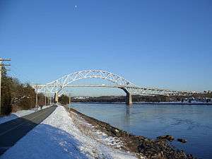
The Bourne Bridge in Bourne, Massachusetts carries Route 28 across the Cape Cod Canal, connecting Cape Cod with the rest of Massachusetts. It won the American Institute of Steel Construction's Class "A" Award of Merit as the "Most Beautiful Steel Bridge" in 1934.[1] Most traffic approaching from the west follows Massachusetts Route 25 which ends at the interchange with US 6 and Route 28 just north of the bridge. The highway provides freeway connections from Interstate 495 and Interstate 195.
There is a six-foot wide[2] sidewalk for pedestrian and bicycle access on the west side of the bridge. The sidewalk is slightly raised, but there is no fence or barrier between it and car traffic, and cyclists are recommended to walk their bicycle.[3] The bridge road is plowed in winter, although the sidewalk is sometimes unplowed and unpassable.[4] Bridges to the Cape are sometimes closed for safety during high winds.[5]
History
The bridge and its sibling the Sagamore Bridge were constructed beginning in 1933 by the Public Works Administration for the United States Army Corps of Engineers, which operates both the bridges and the canal. Each bridge carries four lanes of traffic over a 616-foot (188 m) main span, with a 135-foot (41 m) ship clearance. Construction ended in early 1935 and the bridge opened on June 22, 1935. The approaches to the main span of the Bourne Bridge are considerably longer than those of the Sagamore Bridge due to the topography of the land. The bridge replaces an earlier 1911 drawbridge, and the original drawbridge's approaches are still accessible. The current structure was built to accommodate the widening of the canal.
The bridge commences at a major traffic circle on the Cape Cod end. On the mainland side, New York Central Tugboat 16 sat on dry land at the approach to the bridge from the rotary from 1982 to 2006, serving as a local attraction.[6]
See also
References
- ↑ 50th Anniversary Cape Cod Canal Bridges, Bourne, Massachusetts 1935–1985. Waltham, Massachusetts: U.S. Army Corps of Engineers. 1985. p. 2.
- ↑ "Sagamore And Bourne Bridge Statistics". The Enterprise. 30 January 2015. Retrieved 9 September 2017.
- ↑ Sullivan, John (20 September 2015). "Coffeeneuring the Cape Cod Canal. Both Sides End to End and Crossing Both Bridges". A Midnight Rider. Retrieved 9 September 2017.
- ↑ Burke, Kevin (19 January 2017). "Army Corps: No Snow Clearing From Bridge Sidewalks". The Bourne Enterprise. Retrieved 9 September 2017.
- ↑ "Bourne, Sagamore bridges may close if Hurricane Sandy brings sustained winds of 70 mph". Boston.com. Retrieved October 18, 2014.
- ↑ "Remembering New York Central #16". Tug Boat Enthusiasts Society of the Americas. 2007. Retrieved February 26, 2013.
External links
| Wikimedia Commons has media related to Bourne Bridge. |
Crossings of the Cape Cod Canal | ||||
|---|---|---|---|---|
| ||||