Borgund, Sogn og Fjordane
| Borgund herad | |
|---|---|
| Former Municipality | |
| Municipality ID | NO-1423 |
| Adm. Center | Steinklepp |
| Area[1] | |
| • Total | 635 km2 (245 sq mi) |
| Created from | Lærdal in 1864 |
| Merged into | Lærdal in 1964 |
| Borgund | |
|---|---|
| Village | |
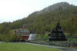 View of the village | |
 Borgund Location in Sogn og Fjordane county  Borgund Borgund (Norway) | |
| Coordinates: 61°02′55″N 07°48′48″E / 61.04861°N 7.81333°ECoordinates: 61°02′55″N 07°48′48″E / 61.04861°N 7.81333°E | |
| Country | Norway |
| Region | Western Norway |
| County | Sogn og Fjordane |
| District | Sogn |
| Municipality | Lærdal Municipality |
| Elevation[2] | 404 m (1,325 ft) |
| Time zone | UTC+01:00 (CET) |
| • Summer (DST) | UTC+02:00 (CEST) |
| Post Code | 6888 Borgund |
Borgund is a village and former municipality in Sogn og Fjordane county, Norway. It is located in the southeastern part of the traditional district of Sogn. The village of Borgund lies along the European route E16 highway, about 20 kilometres (12 mi) southeast of the village of Lærdalsøyri. It is the site of the Borgund Church and the historic Borgund Stave Church.
Borgund was a municipality from 1864 until 1964. It encompassed an area of about 635 square kilometres (245 sq mi) in the eastern part of the present-day municipality of Lærdal. The administrative center of Borgund was the village of Steinklepp, just northeast of the village of Borgund. Steinklepp was the site of a store, a bank, and a school. The historical Filefjell Kongevegen road passes through the Borgund area.[1]
Name
The municipality (originally the parish) was named after the old Borgund farm (Old Norse: Borgyndr), where the historic Borgund Stave Church is located. The name is derived from the old word Borg meaning "fortress" or "stronghold".[3]
Location
The former municipality of Borgund is situated near the southeastern end of the Sognefjorden, along the Lærdalselvi river. The lower parts of the municipality were farms such as Sjurhaugen and Nedrehegg. They are at an elevation of about 270 m (890 ft) above sea level. Høgeloft, on the border with Hemsedal, is a mountain in the Filefjell range and it is the highest point in Borgund at 1,920 m (6,300 ft) above sea level. The lakes Eldrevatnet, Juklevatnet, and Øljusjøen are also located near the border with Hemsedal.
History
Borgund was established as a municipality in 1864 when it was separated from the municipality of Lærdal. At the time of its creation, it had a population of 963. On 1 January 1964, the municipality of Borgund (population: 492), a small part of neighboring Årdal municipality, and the municipality of Lærdal were all merged to form a new, larger municipality of Lærdal.[4]
References
- 1 2 "Borgund – Sogn og Fjordane" (in Norwegian). Store norske leksikon. Archived from the original on 2012-09-29. Retrieved 2009-12-07.
- ↑ "Borgund, Lærdal" (in Norwegian). yr.no. Retrieved 2014-02-26.
- ↑ Rygh, Oluf (1919). Norske gaardnavne: Nordre Bergenhus amt (in Norwegian) (12 ed.). Kristiania, Norge: W. C. Fabritius & sønners bogtrikkeri. p. 74.
- ↑ Jukvam, Dag (1999). "Historisk oversikt over endringer i kommune- og fylkesinndelingen" (PDF) (in Norwegian). Statistisk sentralbyrå.
External links

- Weather information for Borgund (in Norwegian)