Bordeira
For the mountain feature on Mount Fogo in Fogo, Cape Verde, see Bordeira (Fogo)
| Bordeira | ||
|---|---|---|
| Civil parish | ||
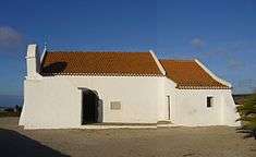
.jpg) The village of Carrapateira | ||
| ||
 Bordeira | ||
| Coordinates: 37°11′46″N 8°51′40″W / 37.196°N 8.861°WCoordinates: 37°11′46″N 8°51′40″W / 37.196°N 8.861°W | ||
| Country | Portugal | |
| Region | Algarve | |
| Subregion | Algarve | |
| Intermunic. comm. | Algarve | |
| District | Faro | |
| Municipality | Aljezur | |
| Area | ||
| • Total | 79.87 km2 (30.84 sq mi) | |
| Elevation | 68 m (223 ft) | |
| Population (2011) | ||
| • Total | 432 | |
| • Density | 5.4/km2 (14/sq mi) | |
| Postal code | 8670 | |
| Area code | 282 | |
| Patron | Nossa Senhora de Encarnação | |
| Website | http://www.cm-aljezur.pt/jfbordeira/ | |

Bordeira is a Portuguese civil parish in the municipality of Aljezur. The population in 2011 was 432,[1] in an area of 79.87 km².[2] It lies within the Southwest Alentejo and Vicentine Coast Natural Park, along the western coast of the Algarve in Faro District. The region, typical of the Algarve coastal areas, is dotted with many beaches, with the most important being the beaches of Praia do Amado and Praia da Carrapateira, which attract both local and tourist vacationers. It contains the village of Carrapateira.
History
Until 1837, the parishes of Carrapateira and Bordeira were actually separate ecclesisastical administrative divisions, of the neighbouring municipality of Vila do Bispo. When these two parishes were converted reallocated during the administrative reforms of Mouzinha de Silveira's government, they were integrated into one parish, and the parish transferred to the settlement of Bordeira which was more secular located in the interior.
Geography

|
|
The civil parish is located along the western coast of Portugal, in the southern limit of the municipality of Sabroa, bordered in the north by the civil parish of Aljezur, east by the parish of Bensafrim and south-east by the parish of Barão de São João (both in the municipality of Lagos and south by the parish of Vila do Bispo (in the municipality of the same name).
The main village of Bordeira is a fairly new one, with wide streets, planted with rows of palms and flowerbeds. It is highlighted by its small chapel, constructed after the 1755 earthquake, heavily carved with gilded interior and retable. The church is dedicated to the patron, Nossa Senhora da Encarnação (Our Lady of the Incarnation).
The parish seat is nestled in a small basin of the Ribeira do Bordeira, surrounded by protected green countryside. Unlike other small villages that are just whitewashed, the buildings in Bordeira are painted with vibrant colours, highlighting the features of each surface. With many small cobble stone roads, orange and lemon trees and fig orchards, the seat resembles a traditional village, with some of the homes staggered above one another. There is a main café, aptly named Café da Bordeira, that offers light snacks and a limited selection for lunch, while shops and other snack bars cater to the local people. Older buildings have been re-purposed to attract more tourists, including the communal bake oven/house, now been converted into living accommodation.
Bordeira is better remembered for its beachfront and sand dunes, popular with surfers who visit Praia da Bordeira for its winds and large waves. Just outside the main village of Bordeira, is a surfing camp.
Architecture
Civic
- Escola Primaria de Carrapateira (Primary School of Carrapateira)
- Museu do Mar e da terra (Museum of the Sea and Land)
Religious
.
- Chapel of Nossa Senhora de Fátima (Our Lady of Fatima) was inaugurated in May 1959.
- Church of Nossa Senhora da Encarnação (Our Lady of the Incarnation), or Matriz Church of Bordeira, was constructed following the 1755 earthquake and tsunami, in a simple style consisting of one nave, presented by a triumphal arch, high altar, with Baroque era styling, but with a Manueline-era portico that gives access to the local cemetery (which was not its original function);
- Church of Nossa Senhora da Conceição (and Fort of Carrapateira), the 17th-century fortress and religious platform that protected the village of Carrapateira until the end of the 18th century
References
- Notes
- ↑ Instituto Nacional de Estatística
- ↑ Direção-Geral do Território
- ↑ Vila do Bispo: Curiosidades sobre a sua História (PDF) (in Portuguese), 2005, archived from the original (PDF) on 7 July 2011, retrieved 10 August 2011
- Sources
- Callixto, Carlos Pereira (October 1983), "As Fortificações dependentes da Praça de sagres: O Forte da Carrapateira", Revista da Marinha (in Portuguese) (130), Lisbon, Portugal