Boquer Valley
| Boquer Valley | |
|---|---|
| Val de Boquer | |
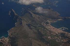 Boquer Valley (centre) and Port de Pollença, from the air | |
| Location | Port de Pollença, Majorca |
| Long-axis direction | NE |
| Long-axis length | 3 kilometres (1.9 mi) |
| Geography | |
| Coordinates | 39°55′23″N 3°05′17″E / 39.923°N 3.088°ECoordinates: 39°55′23″N 3°05′17″E / 39.923°N 3.088°E |
The Boquer Valley (Catalan: Vall de Boquer) is a scenic valley running 3 kilometres (1.9 mi) north-east from the town of Port de Pollença, Majorca, to the sea at Cala Boquer. It is popular with bird-watchers for its migratory birds and resident Blue Rock Thrushes.[1]
The ridge to the north-west, the Serra del Cavall Bernat, drops, on the other side, 360 metres (1,180 ft) to the sea.[2] The ridge on the south-east side includes a peak called El Morral, which reaches 353 metres (1,158 ft).

Finca Boquer
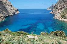
Cala Boquer
The valley is only accessible by foot.[2] The inland end is marked by a finca called Finca Boquer. The Roman city of Bocchoris, which gives name to the valley, presumably lay here.[3][4]
References
| Wikimedia Commons has media related to Boquer Valley. |
- ↑ "Birding in The Boquer Valley Itinerary". Birding in Spain.com. Retrieved 7 May 2012.
- 1 2 "The Boquer Valley". Retrieved 7 May 2012.
- ↑ "La civitas Bocchoritana: una cuestión abierta". García Riaza, E. Revista d'Arqueologia de Ponent, 9, 1999, 75-81. Retrieved 29 October 2012.
- ↑ "Oppidum Bochoritanum". The Princeton Encyclopedia of Classical Sites. Retrieved 29 October 2012.
This article is issued from
Wikipedia.
The text is licensed under Creative Commons - Attribution - Sharealike.
Additional terms may apply for the media files.