Booger Tree, Alabama
| Booger Tree, Alabama | |
|---|---|
| Unincorporated community | |
 Booger Tree, Alabama | |
| Coordinates: 34°11′11″N 87°31′5″W / 34.18639°N 87.51806°WCoordinates: 34°11′11″N 87°31′5″W / 34.18639°N 87.51806°W | |
| Country | United States |
| State | Alabama |
| County | Winston |
| Elevation | 846 ft (258 m) |
| Time zone | UTC-6 (Central (CST)) |
| • Summer (DST) | UTC-5 (CDT) |
| GNIS feature ID | 2680801[1] |
Booger Tree was an unincorporated community in Winston County, Alabama, United States.
References
Municipalities and communities of Winston County, Alabama, United States | ||
|---|---|---|
| City | 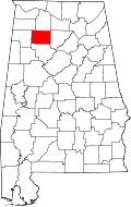 | |
| Towns | ||
| Unincorporated communities | ||
| Ghost town | ||
| Footnotes | ‡This populated place also has portions in an adjacent county or counties | |
This article is issued from
Wikipedia.
The text is licensed under Creative Commons - Attribution - Sharealike.
Additional terms may apply for the media files.