Bongdam
| Bongdam 봉담 峰潭 | |
|---|---|
| Town | |
| Korean transcription(s) | |
| • Hangul | 봉담읍 |
| • Hanja | 峰潭邑 |
| • Revised Romanization | Bongdam-eup |
| • McCune-Reischauer | Pongdam-ŭp |
 Bongdam Location in South Korea | |
| Coordinates: 37°13′12″N 126°56′58″E / 37.22000°N 126.94944°E | |
| Country |
|
| Region | Sudogwon |
| Administrative divisions | 16 ri |
| Area | |
| • Total | 42.703 km2 (16.488 sq mi) |
| Population (January 2011) | |
| • Total | 67,694 |
| • Density | 1,585.2/km2 (4,106/sq mi) |
| • Dialect | Seoul |
Bongdam is a town in the city of Hwaseong in South Korea. Covering over 4000 hectares, the town is the focus of a planned community, primarily as a commuter town for the bordering city of Suwon.
History
- April 1, 1914: Suwon-gun (수원군)'s Sambong-myeon (삼봉면 - 三峰面) and Galdam-myeon (갈담면 - 葛潭面) were combined, forming Bongdam-myeon (봉담면 - 峰潭面), a town of 15 villages.
- August 14, 1949: As Suwon-eup was raised in status to Suwon-bu, the remainder of Suwon-gun was renamed Hwaseong-gun. (Suwon-bu became a city soon afterwards.)
- February 15, 1983: Bibong-myeon's village of Sanggi-ri left Bibong-myeon and became part of Bongdam-myeon, completing the 16 villages which remain in Bongdam today.
- May 1992: Bongdam-myeon's council office moved from 31-3 Sang-ri to the nearby newly constructed facility at 27-1 Sang-ri.
- April 1, 1998: Bongdam's status was raised from myeon to eup.
- March 21, 2001: Hwaseong's status was raised from gun (county) to si (city).
- March 20, 2008: Much of the housing in Donghwa-ri was cleared for a new housing development.
Geography
Bongdam is bounded to the north-west by the hills of Sambongsan (삼봉산 - 三峰山: 271m) and Taehaengsan (태행산 - 太行山: 266m), to the west by Geocheon Reservoir and Geondalsan (건달산 - 建達山: 328m), to the south-west by Deogu Reservoir and Cheolmasan (철마산 - 鐵馬山: 123m), to the south-east by Seobongsan (서봉산 - 棲鳳山: 250.3m), to the east by Taebongsan (태봉산 - 太鳳山: 224m) and Botong Reservoir, and to the north-east by Gogeumsan (고금산 - 古琴山: 87m) and the city of Suwon. No major streams pass through the town, though its plain is drained in entirety to Sihwa.
Demographics
Bongdam's population is currently increasing, and this is expected to continue as further housing developments are planned. The foreign population stands at 4.6%, approximately double the national average.[1]
Administrative divisions
Bongdam is divided into 16 ri (villages):
- Buncheon-ri (분천리)
- Dangha-ri (당하리)
- Deogu-ri (덕우리)
- Deok-ri (덕리)
- Donghwa-ri (동화리)
- Hagadeung-ri (하가등리)
- Maha-ri (마하리)
- Nae-ri (내리)
- Sanggi-ri (상기리)
- Sang-ri (상리)
- Segok-ri (세곡리)
- Sugi-ri (수기리)
- Suyeong-ri (수영리)
- Wangnim-ri (왕림리)
- Wau-ri (와우리)
- Yu-ri (유리)
Education
Bongdam is home to six institutes of higher education: the University of Suwon, Hyupsung University, Suwon Catholic University, the Haeran Campus of Suwon Women's University, Jangan College, and Korea National College of Agriculture and Fisheries. The town also has a high school, three middle schools and seven primary schools.[2]
Transport
Rail
Trains on the former Suin Line used to pass through Suyeong-ri in the far north of Bongdam. The Suin Line is currently being reconstructed and will form part of the Seoul Subway network. It is planned for a station named Bongdam, two stops from Suwon, to be operating by 2012, though this station will be just outside Bongdam, in Suwon's Omokcheon-dong. Also, all KTX trains pass through Bongdam, though the town does not have a station on this line.
Road
Bongdam has an interchange on combined motorways 17 and 400.
Culture
The Baekje tombs in Maha-ri and other important graves - those of Lee Gon (이곤) in Sang-ri, and Buncheon-ri's tombs of Seo Geojeong (서거정) and Choi Rubaek (최루백), are among the oldest significant remains in Bongdam. There are also two older Buddhist temples: Beopheungsa in Sugi-ri, Bogwangsa in Wangnim-ri.
Gallery
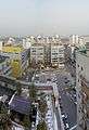 Bongdam's central square
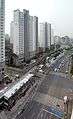 Road past Bongdam Centre
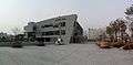 Hwaseong Sports Centre
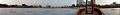 Lake by Bongdam Council Office
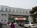 Bongdam Council Office
 Bongdam Public Library
References
- ↑ "인구현황 Inguhyeonhwang". Hwaseong City Council. Retrieved 2011-02-15.
- ↑ "화성시청봉담읍사무소우리마을소개 Hwaseongsicheong Bongdameupsamuso Urimaeulsogae". Hwaseong City Council. Retrieved 2011-02-14.
External links
Coordinates: 37°13′12″N 126°56′58″E / 37.22000°N 126.94944°E