Boltby
| Boltby | |
|---|---|
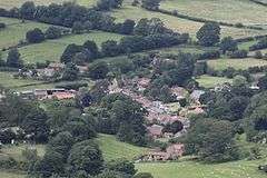 Village of Boltby from the Cleveland Way | |
 Boltby Boltby shown within North Yorkshire | |
| Population | 143 (2011 census)[1] |
| OS grid reference | SE491866 |
| Civil parish |
|
| District | |
| Shire county | |
| Region | |
| Country | England |
| Sovereign state | United Kingdom |
| Post town | THIRSK |
| Postcode district | YO7 |
| Police | North Yorkshire |
| Fire | North Yorkshire |
| Ambulance | Yorkshire |
| EU Parliament | Yorkshire and the Humber |
| UK Parliament | |
Boltby is a village and civil parish in the Hambleton district of North Yorkshire, England. It is on the edge of the North York Moors National Park at 140 m, and about six miles north-east of Thirsk. According to the 2011 census, it had a population of 143.[1]
History
Boltby is mentioned in the Domesday Book as Boltebi in the Yalestre hundred. After the Norman invasion, the land was owned by Hugh, son of Baldric. He granted Lordship of the local manor to Gerald of Boltby. Previously the Lord of the manor was Sumarlithi, son of Karli.[2]
Although now without a public house, it had four during the building of a reservoir and water supply to Thirsk. The last of these, The Johnstone Arms, is now a farm and riding stables. Fewer than five new houses have been built in the village in the 20th century, giving a total of 43 in 2005.
One oddity of the village is a deed giving free water 'in perpetuity' to the buildings in the area. This dates from the late 19th century when the new reservoir was built and water piped through the land of Ravensthorp manor.
The eastern part of the village was badly affected by the flooding in 2005 when the Gurtof Beck overflowed and damaged or destroyed several buildings. The local reports were of water levels between 2-3m deep.[3]
Governance
The village lies within the Thirsk and Malton UK Parliament constituency. It is part of the Thirsk electoral division of North Yorkshire County Council and the Whitestonecliffe ward of Hambleton District Council.[4]
The parish shares a grouped parish council, known as Hillside Parish Council, with the civil parishes of Cowesby, Felixkirk, Kirby Knowle and Upsall.[5]
Geography
According to the 1881 UK Census, the population was 317.[6] The 2001 UK Census recorded the population as 149, of which 124 were over the age of sixteen with 81 in employment. There are 70 dwellings of which 52 are detached.[7] The population at the 2011 Census had reduced slightly to 143.[8]
The low level geology of the area is of Devensian clay on beds of lower Jurassic lias.[3]
The village lies 1.4 miles (2.3 km) west of the Cleveland Way National Trails. It is also 1.2 miles (1.9 km) south-east of Boltby Reservoir, which was built in 1882. The reservoir is 14.1 metres (46 ft) deep and covers an area of 3.1 hectares (7.7 acres) from a catchment are of 3.41 square kilometres (1.32 sq mi).[9]
The village is located 1.3 miles (2.1 km) south-east of Kirby Knowle; 1.8 miles (2.9 km) north-east of Felixkirk; 1.6 miles (2.6 km) north of Thirlby and 3 miles (4.8 km) north-west of Cold Kirby which are the nearest settlements.[4]
Religion
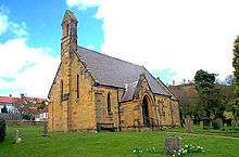
There is one church in the village, dedicated to the Holy Trinity. The modern building was rebuilt around 1856 on the site of the earlier churches, re-built around 1409 and 1802 respectively.[6] Parish registers date from around 1600.[10]
Notable buildings
There are nine Grade II Listed Buildings in the village and nearby area. These include the bridge over Gurtof Beck.[11] About 0.5 miles (0.80 km) west of the village is Ravensthorpe Manor, built in the mid 19th century on the site of a castle that used to belong to the De Ros family.[6][12]
References
- 1 2 UK Census (2011). "Local Area Report – Boltby Parish (1170216806)". Nomis. Office for National Statistics. Retrieved 10 March 2018.
- ↑ Boltby in the Domesday Book. Retrieved 21 December 2012.
- 1 2 Yorkshire Geological Society Circular 525 (PDF). 2005. p. 9. Retrieved 21 December 2012.
- 1 2 Ordnance Survey Open Viewer
- ↑ "Hillside Parish Council". Hambleton District Council. Retrieved 7 March 2017.
- 1 2 3 Bulmer's Topography, History and Directory (Private and Commercial) of North Yorkshire 1890. S&N Publishing. 1890. p. 699. ISBN 1-86150-299-0.
- ↑ "2001 UK Census". Retrieved 21 December 2012.
- ↑ "Parish population 2011". Retrieved 2 August 2015.
- ↑ Human Impact on Erosion and Sedimentation (Proceedings of the Rabat Symposium, April 1997) (PDF). 1997. p. 172. Retrieved 21 December 2012.
- ↑ "Church". Retrieved 21 December 2012.
- ↑ "Grade II Listed Buildings". Retrieved 21 December 2012.
- ↑ "Ravensthorpe Hall Listing". Retrieved 21 December 2012.
Further reading
- Boltby Millennium Group. Boltby: A History. 2002.