Bolsterlanger Horn
| Bolsterlanger Horn | |
|---|---|
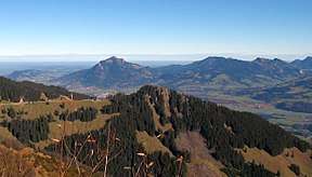 The Bolsterlanger Horn in the centre. Behind the Grünten | |
| Highest point | |
| Elevation | 1,586.2 m above sea level (NN) (5,204 ft) |
| Prominence | 46 m ↓ Col between the it and the Weiherkopf |
| Isolation | 0.6 km → Weiherkopf |
| Coordinates | 47°27′34″N 10°12′30″E / 47.45944°N 10.20833°ECoordinates: 47°27′34″N 10°12′30″E / 47.45944°N 10.20833°E |
| Geography | |
| Parent range | Prealps west of the Iller, Allgäu Alps |
| Geology | |
| Mountain type | grass mountain |
| Type of rock | flysch |
| Climbing | |
| First ascent | by locals |

The Bolsterlanger Horn is a grass mountain in the Allgäu Alps in Bavaria. Because its 1,586-metre-high summit rises above Bolsterlang, it is the local mountain (Hausberg) of this village. The Bolsterlanger Horn is part of the Hörner group and its southernmost peak. The topographic prominence of the Bolsterlanger Horn is at least 46 metres,[1] its isolation is 600 metres, the Weiherkopf being the reference summit.[2]
Ascent
The normal route runs from the top station of the Hörnerbahn along a forest path and only takes about 10 minutes walk to the top.
Features
In 2009 the path to the summit from the Hörnerbahn was made into a "reflection" walk.
Summit cross
At the top is a summit cross with mirrors which light up in the sunshine.
References and footnotes
- ↑ The exact value is unknown; the given value is a minimum (- it could be around 19 m more). It was estimated from the spacing of the 20 m contour lines on the 1:25,000 scale map of the area.
- ↑ Bavarian Survey Department: BayernViewer 2.0. Retrieved 26 May 2011.
External links
This article is issued from
Wikipedia.
The text is licensed under Creative Commons - Attribution - Sharealike.
Additional terms may apply for the media files.