Bollons Island
 Bollons Island, as seen from near Antipodes Island | |
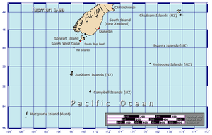 Position relative to New Zealand and other outlying islands | |
| Geography | |
|---|---|
| Coordinates | 49°38′42″S 178°49′09″E / 49.645°S 178.819167°E |
| Archipelago | Antipodes Islands |
| Major islands | Antipodes Island, Bollons Island |
| Area | 2 km2 (0.77 sq mi) |
| Highest elevation | 202 m (663 ft) |
| Administration | |
|
New Zealand | |
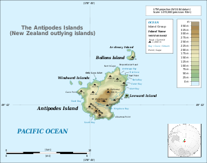
Bollons Island (49°38′42″S 178°49′09″E / 49.645°S 178.819167°ECoordinates: 49°38′42″S 178°49′09″E / 49.645°S 178.819167°E) is a small island in New Zealand's subantarctic Antipodes Islands group. It is the second largest island in the group behind Antipodes Island.
Geography
The island is roughly crescent-shaped, and has an area of 2 km2 (0.77 sq mi). It lies to the northeast of the group's main island, Antipodes Island, separated from it by a 1200-metre wide strait. The smaller Archway Island lies immediately to the northwest of Bollons Island.
Bollons Island is dominated by a curved ridge running the length of the island, with a highest point 202 metres (663 ft) above sea level. Cliffs surround the island on all sides except the west.
History
The island is named after John Bollons, Master of the New Zealand Marine Department vessels, NZGSS Hinemoa and SS Tutanekai.
Important Bird Area
The island is part of the Antipodes Islands Important Bird Area (IBA), identified as such by BirdLife International because of the significance of the group as a breeding site for several species of seabirds.[1]
See also
Further reading
- Taylor, Rowley, (2006) Straight Through from London, the Antipodes and Bounty Islands, New Zealand.Christchurch: Heritage Expeditions New Zealand Ltd. ISBN 0-473-10650-7.
References
- ↑ BirdLife International. (2012). Important Bird Areas factsheet: Antipodes Islands. Downloaded from "Archived copy". Archived from the original on 2007-07-10. Retrieved 2013-04-19. on 2012-01-27.