Boldecker Land
| Boldecker Land | ||
|---|---|---|
| ||
 Boldecker Land Location of Boldecker Land within Gifhorn district 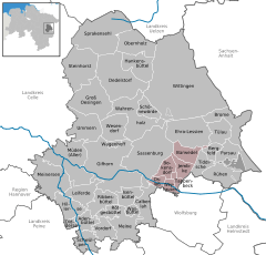  | ||
| Coordinates: 52°28′N 10°43′E / 52.467°N 10.717°ECoordinates: 52°28′N 10°43′E / 52.467°N 10.717°E | ||
| Country | Germany | |
| State | Lower Saxony | |
| District | Gifhorn | |
| Government | ||
| • Mayor | Lothar Leusmann | |
| Area | ||
| • Total | 69.56 km2 (26.86 sq mi) | |
| Elevation | 56 m (184 ft) | |
| Population (2017-12-31)[1] | ||
| • Total | 9,916 | |
| • Density | 140/km2 (370/sq mi) | |
| Time zone | CET/CEST (UTC+1/+2) | |
| Vehicle registration | GF | |
| Website | Boldecker-Land.de | |

Boldecker Land is a municipality in the district of Gifhorn, in Lower Saxony, Germany. It is situated along the river Aller, approx. 12 km east of Gifhorn, and 8 km northwest of Wolfsburg. Its seat is in the village Weyhausen.
Politics
Samtgemeinde council
Structure of Boldecker Land
| Structure of the Municipality | ||||
|---|---|---|---|---|
| Town | Inhabitants (31. June 2005) | Surface: in km² | Population density in Inh../km² | |
| Barwedel | 1 077 | 19.8 | 54 | |
| Bokensdorf | 950 | 14.49 | 66 | |
| Jembke | 1 936 | 14.57 | 133 | |
| Tappenbeck | 1 329 | 5.11 | 260 | |
| Osloß | 1 981 | 7.64 | 259 | |
| Weyhausen | 2 648 | 7.98 | 332 | |
References
External links
| Wikimedia Commons has media related to Gifhorn/Boldecker Land. |
| Authority control |
|---|
This article is issued from
Wikipedia.
The text is licensed under Creative Commons - Attribution - Sharealike.
Additional terms may apply for the media files.