Bolívar Municipality, Táchira
| Bolívar Municipality Municipio Bolívar | |||
|---|---|---|---|
| Municipality | |||
| |||
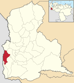 Location in Táchira | |||
.svg.png) Bolívar Municipality Location in Venezuela | |||
| Coordinates: 7°49′N 72°27′W / 7.82°N 72.45°WCoordinates: 7°49′N 72°27′W / 7.82°N 72.45°W | |||
| Country |
| ||
| State | Táchira | ||
| Municipal seat | San Antonio del Táchira | ||
| Government | |||
| • Mayor | Juan Vicente Cañas Alviarez (MVR) | ||
| Area | |||
| • Total | 198 km2 (76 sq mi) | ||
| Population (2007) | |||
| • Total | 60,149 | ||
| • Density | 300/km2 (790/sq mi) | ||
| Time zone | UTC−04:00 (VET) | ||
| Area code(s) | 0276 | ||
| Website | Official website | ||

Bolívar Municipality is one of the 29 municipalities that makes up the western Venezuelan state of Táchira and, according to a 2007 population estimate by the National Institute of Statistics of Venezuela, the municipality has a population of 60,149.[1] The town of San Antonio del Táchira is the shiretown of the Bolívar Municipality.[2]
Name
The municipality is one of several in Venezuela named "Bolívar Municipality" in honour of Venezuelan independence hero Simón Bolívar.
Demographics
The Bolívar Municipality, according to a 2007 population estimate by the National Institute of Statistics of Venezuela, has a population of 60,149 (up from 50,209 in 2000). This amounts to 5.1% of the state's population.[3] The municipality's population density is 294.85 inhabitants per square kilometre (763.7/sq mi).[4]
Government
The mayor of the Bolívar Municipality is Juan Vicente Cañas Alviarez, elected on October 31, 2004 with 48% of the vote.[5] He replaced Ramon Vivas shortly after the elections.[6] The municipality is divided into four parishes; Bolívar, Palotal, Juan Vicente Gómez, and Isaías Medina Angarita (parishes Juan Vicente Gómez and Isaías Medina Angarita were officially separated from the Bolívar parish on January 25, 1995).[2]
References
- ↑ http://www.ocei.gov.ve/sintesisestadistica/estados/tachira/cuadros/Poblacion6.xls%5Bpermanent+dead+link%5D
- 1 2 http://www.ocei.gov.ve/secciones/division/Tachira.zip%5Bpermanent+dead+link%5D
- ↑ http://www.ocei.gov.ve/sintesisestadistica/estados/tachira/cuadros/Poblacion5.xls%5Bpermanent+dead+link%5D
- ↑ "Archived copy". Archived from the original on 2008-10-31. Retrieved 2008-03-12.
- ↑ http://www.cne.gob.ve/regionales2004/18/alcaldedis=0&edo=18&mun=2&par=0&cen=0&mesa=0&cua=0.html
- ↑ "Archived copy" (PDF). Archived from the original (PDF) on 2006-10-02. Retrieved 2008-03-15.
External links
- bolivar-tachira.gob.ve (in Spanish)
- Information on the Bolívar Municipality (in Spanish)
- More information on the Bolívar Municipality (in Spanish)