Boeun County
| Boeun 보은군 | |
|---|---|
| County | |
| Korean transcription(s) | |
| • Hangul | 보은군 |
| • Hanja | 報恩郡 |
| • Revised Romanization | Boeun-gun |
| • McCune-Reischauer | Poŭn-gun |
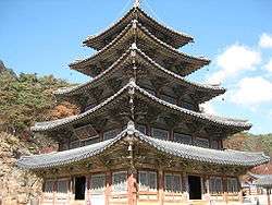 Palsangjeon hall at Beopjusa temple | |
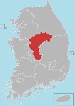
 Location in South Korea | |
| Country |
|
| Region | Hoseo |
| Administrative divisions | 1 eup, 10 myeon |
| Area | |
| • Total | 584.45 km2 (225.66 sq mi) |
| Population (2001) | |
| • Total | 43,245 |
| • Density | 74/km2 (190/sq mi) |
| • Dialect | Chungcheong |
Boeun County (Boeun-gun) is a county in North Chungcheong Province, South Korea.
History
Boeun, literally "offering gratitude" or "thanksgiving", was named in 1406 by a remorseful King Taejong, who felt relieved that he had cleared his conscience after having participated at a ceremonial ritual at the local Beopjusa temple to appease the spirits of his dead younger half-brothers. Boeun is in South Korea. He had caused their deaths during a power struggle years previously.[1]
In July 1973, Boeun township was elevated to the status of Boeun town.[2] In 1983, two townships were abolished and incorporated into normal ones. In 2007, Hoebuk-myeon changed its name to Hoein-myeon, Oesongni-myeon to Jangan-myeon, and Naesonngni-myeon into Songnisan-myeonn.[3]
Festivals
- Songnisan Fall Festival: During autumn a festival is held at Songnisan, a celebrated mountain in central Korea. The festival has been an important contributor to the development of tourism and the economy in the region.[4]
- Boeun Ocher Apple Festival: Boeun County is well known for its apples, for which a major festival is held to promote them.
Products
Jujube is the most well-known agricultural product in Boeun county. Additionally, the county's fruit, and eggs are growing in popularity thanks to their eco-friendly mark.[5]
Climate
| Climate data for Boeun (1981–2010, extremes 1971–present) | |||||||||||||
|---|---|---|---|---|---|---|---|---|---|---|---|---|---|
| Month | Jan | Feb | Mar | Apr | May | Jun | Jul | Aug | Sep | Oct | Nov | Dec | Year |
| Record high °C (°F) | 14.4 (57.9) |
20.6 (69.1) |
26.2 (79.2) |
31.2 (88.2) |
34.2 (93.6) |
33.4 (92.1) |
36.5 (97.7) |
36.2 (97.2) |
32.8 (91) |
29.0 (84.2) |
25.1 (77.2) |
17.4 (63.3) |
36.5 (97.7) |
| Average high °C (°F) | 2.7 (36.9) |
5.4 (41.7) |
11.2 (52.2) |
18.7 (65.7) |
23.4 (74.1) |
26.7 (80.1) |
28.6 (83.5) |
29.4 (84.9) |
25.3 (77.5) |
19.9 (67.8) |
12.4 (54.3) |
5.4 (41.7) |
17.4 (63.3) |
| Daily mean °C (°F) | −3.4 (25.9) |
−1.0 (30.2) |
4.3 (39.7) |
11.1 (52) |
16.4 (61.5) |
20.8 (69.4) |
23.8 (74.8) |
24.1 (75.4) |
18.8 (65.8) |
12.0 (53.6) |
5.2 (41.4) |
−1.0 (30.2) |
10.9 (51.6) |
| Average low °C (°F) | −9.0 (15.8) |
−6.9 (19.6) |
−2.1 (28.2) |
3.4 (38.1) |
9.5 (49.1) |
15.3 (59.5) |
19.9 (67.8) |
20.0 (68) |
13.6 (56.5) |
5.6 (42.1) |
−0.8 (30.6) |
−6.5 (20.3) |
5.2 (41.4) |
| Record low °C (°F) | −25.4 (−13.7) |
−21.9 (−7.4) |
−18.3 (−0.9) |
−7.4 (18.7) |
−1.2 (29.8) |
4.6 (40.3) |
10.4 (50.7) |
9.4 (48.9) |
0.8 (33.4) |
−7.0 (19.4) |
−12.3 (9.9) |
−20.4 (−4.7) |
−25.4 (−13.7) |
| Average precipitation mm (inches) | 27.3 (1.075) |
32.4 (1.276) |
48.7 (1.917) |
73.1 (2.878) |
94.7 (3.728) |
159.3 (6.272) |
313.0 (12.323) |
290.3 (11.429) |
143.1 (5.634) |
45.0 (1.772) |
44.1 (1.736) |
26.4 (1.039) |
1,297.4 (51.079) |
| Average precipitation days (≥ 0.1 mm) | 7.8 | 7.5 | 8.7 | 7.6 | 8.2 | 9.6 | 16.0 | 14.6 | 9.3 | 6.0 | 8.0 | 8.1 | 111.4 |
| Average snowy days | 8.9 | 6.7 | 2.8 | 0.2 | 0.0 | 0.0 | 0.0 | 0.0 | 0.0 | 0.2 | 2.0 | 6.6 | 27.2 |
| Average relative humidity (%) | 68.6 | 66.2 | 63.4 | 60.2 | 65.3 | 71.4 | 77.5 | 78.4 | 77.1 | 73.8 | 71.2 | 70.0 | 70.3 |
| Mean monthly sunshine hours | 172.9 | 178.3 | 212.7 | 234.3 | 249.0 | 217.7 | 178.9 | 194.7 | 191.3 | 209.2 | 165.5 | 162.8 | 2,368.2 |
| Percent possible sunshine | 55.9 | 58.2 | 57.4 | 59.5 | 57.0 | 49.7 | 40.1 | 46.4 | 51.3 | 59.9 | 53.8 | 54.0 | 53.2 |
| Source: Korea Meteorological Administration[6][7][8] (percent sunshine and snowy days)[9] | |||||||||||||
Symbols
- City Flower: Forsythia
- City Tree: Jujube tree
- City Bird: Magpie Birds
Twin towns – sister cities
Boeun is twinned with:
References
- ↑ Official website, Origin
- ↑ Regulations concerning establishment of towns (eups)(1973-03-12)
- ↑ Allowance of alteration concerning from cities to townships (ris)(1983-01-10) from Constitution of the Republic of Korea Currently, Boeun is composed of 1 eup (Boeun-eup) and 10 myons. One of the myons, Maro-myon of which capital is kwanki-ri is famous for Han-woo (Korean traditional cow) and the beautiful scenery in Ku-byong mountain.
- ↑ Official page of Boeun County http://english.boeun.go.kr/
- ↑ 보은군내 친환경농산물인증 농가 2배 증가 The confirmation of eco mark doubles Newsis 2008-01-10
- ↑ "평년값자료(1981–2010) 보은(226)" (in Korean). Korea Meteorological Administration. Retrieved 2011-05-01.
- ↑ "기후자료 극값(최대값) 전체년도 일최고기온 (℃) 최고순위, 보은(226)" (in Korean). Korea Meteorological Administration. Retrieved 20 February 2017.
- ↑ "기후자료 극값(최대값) 전체년도 일최저기온 (℃) 최고순위, 보은(226)" (in Korean). Korea Meteorological Administration. Retrieved 20 February 2017.
- ↑ "Climatological Normals of Korea" (PDF). Korea Meteorological Administration. 2011. p. 499 and 649. Archived from the original (PDF) on 7 December 2016. Retrieved 20 February 2017.
External links
| Wikimedia Commons has media related to Boeun. |
Coordinates: 36°29′04″N 127°43′07″E / 36.4844444544°N 127.718611121°E