Blues Old Stand, Alabama
| Blues Old Stand, Alabama | |
|---|---|
| Unincorporated community | |
 Blues Old Stand, Alabama  Blues Old Stand, Alabama | |
| Coordinates: 31°59′06″N 85°43′01″W / 31.98500°N 85.71694°WCoordinates: 31°59′06″N 85°43′01″W / 31.98500°N 85.71694°W | |
| Country | United States |
| State | Alabama |
| County | Bullock |
| Elevation | 472 ft (144 m) |
| Time zone | UTC-6 (Central (CST)) |
| • Summer (DST) | UTC-5 (CDT) |
| Area code(s) | 334 |
| GNIS feature ID | 114601[1] |
Blues Old Stand is an unincorporated community in Bullock County, Alabama, United States. The main road through the community is U.S. Route 29 in Alabama, but also includes Bullock County Roads 14 and 19. Blue Old Stand serves as the home of the Master Rack Hunting Lodge.[2]
History
According to one account, Blues Old Stand was named for a man named Blue who kept a store known locally as the 'stand'.[3]
References
- ↑ "Blues Old Stand". Geographic Names Information System. United States Geological Survey.
- ↑ Master Rack Lodge - Directions
- ↑ Gallant, Frank K. (2012). A Place Called Peculiar: Stories about Unusual American Place-Names. Courier Dover Publications. p. 3.
Municipalities and communities of Bullock County, Alabama, United States | ||
|---|---|---|
| Cities | 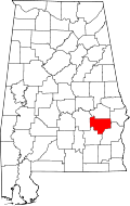 | |
| Towns | ||
| CDP | ||
| Unincorporated communities | ||
| Ghost towns | ||
This article is issued from
Wikipedia.
The text is licensed under Creative Commons - Attribution - Sharealike.
Additional terms may apply for the media files.