Blue Banana
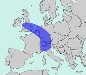
The Blue Banana (French: banane bleue, also known as the European Megalopolis or the Manchester–Milan Axis) is a discontinuous corridor of urbanisation spreading over Western and Central Europe, with a population of around 111 million.[1] The concept was developed in 1989 by RECLUS, a group of French geographers managed by Roger Brunet.[2]
It stretches approximately from North Wales across Greater London to the Benelux states and along the German Rhineland, Southern Germany, Alsace in France in the west and Switzerland to Northern Italy in the south.[3][4]
History
The French geographer Roger Brunet, who observed a division between "active" and "passive" spaces, developed the concept of a West European "backbone" in 1989. He made reference to an urban corridor of industry and services stretching from northern England to northern Italy.[2] The name "Blue Banana" was dually coined by Jacques Chérèque, and an artist adding a graphic to an article by Josette Alia in Le Nouvel Observateur. The color blue referred to either the color of the flag of the European Community, or the blue collars of the factory workers in the region.[5]
Brunet saw the "European Backbone" as the development of historical precedents, e.g. trade routes, or as the consequence of an accumulation of industrial capital. In his analysis, Brunet excluded the Paris urban area and other French conurbations because of French economic insularity. His aim was a greater economic integration in Europe, but he felt that France had lost this connection by the 17th century. as a result of its persecution of Huguenots and centralisation in Paris.[6][5] Later versions do, however, include Paris.[6]
In 1991, in the context of a study on behalf of the European Commission in support of its Regional Policy, researchers criticized the idea of the Blue Banana as a desirable formation, but not its empirical reality, identifying it the result of regional competition in Europe. Furthermore, their diagram of the Blue Banana had more of a curve, still including Northern Italy, but ending at Barcelona. It also included Paris, and had the Anglo-Scottish border as its northern stem.[7] A study of the history of the Blue Banana as a concept refers to the Commission's study as a mistaken rejection of the Blue Banana from Brunet's original conception. From the research on the Commission's behalf, the Blue Banana represented a developed core at the expense of the periphery, whereas Brunet empirically viewed the Blue Banana as a region of development at Paris's periphery, beyond the French borders.[8]
See also
References
- ↑ "The European Blue Banana". Eu-partner.com. 3 March 2011. Archived from the original on 6 October 2014. Retrieved 14 September 2013.
- 1 2 Brunet, Roger (1989). Les villes europeénnes: Rapport pour la DATAR (in French). Montpellier: RECLUS. ISBN 2-11-002200-0.
- ↑ Gert-Jan Hospers (2002). Beyond the Blue Banana? Structural Change in Europe's Geo-Economy (PDF). 42nd EUROPEAN CONGRESS of the Regional Science Association Young Scientist Session – Submission for EPAINOS Award 27–31 August 2002. Dortmund, Germany. Retrieved 2006-09-27.
- ↑ Gert-Jan Hospers (2003). "Beyond the Blue Banana? Structural Change in Europe's Geo-Economy" (PDF). Intereconomics. 38 (2): 76–85. doi:10.1007/BF03031774. Retrieved 2006-09-27.
- 1 2 Jacobs, Frank. "The Blue Banana - the True Heart of Europe". Big Think: Your Daily Microdose of Genius. The Big Think, Inc. Retrieved 4 March 2018.
- 1 2 Taylor, Paul. "No more Blue Banana, Europe's industrial heart moves east". Reuters. Retrieved 4 March 2018.
- ↑ Kunzmann, Klaus R.; Wegener, Michael (September 1991). "The pattern of urbanization in Western Europe" (PDF). Ekistics. 350: 291. Retrieved 4 March 2018.
- ↑ Faludi, Andreas (March 2015). "The 'Blue Banana' Revisited" (PDF). European Journal of Spatial Development. 56. Retrieved 3 March 2018.
- Geza, Tóth; Nagy, Zoltán; Kincses, Áron (2014). European Spatial Structure. Saarbrücken: Lambert Academic Publishing. doi:10.13140/2.1.1560.2247. ISBN 978-3-659-64559-4.
- Brunet, Roger (April 2002). "Lignes de force de l'espace Européen" (PDF). Mappemonde (in French) (66): 14–19.