Blue Hole (New Mexico)
| Blue Hole New Mexico | |
|---|---|
 | |
| Location | Guadalupe County, near Santa Rosa, New Mexico |
| Coordinates | 34°56′26″N 104°40′24″W / 34.940447°N 104.673239°WCoordinates: 34°56′26″N 104°40′24″W / 34.940447°N 104.673239°W |
| Basin countries | United States |
| Max. width | 80 ft (24 m) |
| Max. depth | >80 ft (24 m) |
| Surface elevation | 4,600 ft (1,400 m) |
| Frozen | never |
| Islands | none |
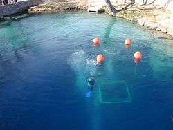
The Blue Hole of Santa Rosa is a circular, bell-shaped pool east of Santa Rosa, New Mexico that is one of the most popular dive destinations in the US[1] for SCUBA diving and training. The Blue Hole is an artesian well that was once used as a fish hatchery.[2] It is a clear blue body of water with a constant 62 °F (17 °C) temperature and constant inflow of 3,000 US gallons per minute (11 m3/min; 2,500 imp gal/min). While the surface is only 80 feet (24 m) in diameter, it expands to a diameter of 130 feet (40 m) at the bottom.[3]
Since Santa Rosa, New Mexico is at an elevation of 4,616 ft (1,407 m), it is necessary for divers to use high-altitude dive tables to compute the dive profile and decompression stops when diving in the Blue Hole.
The pool is open for public use with no lifeguards on duty.
On March 26, 2016, 43-year-old California diver Shane Thompson, a Navy veteran from the ADM Exploration Foundation, was exploring passageways where he became trapped and drowned.
See also
References
- ↑ Sachs, Andrea (2004-12-19). "On Route 66, the Blue Hole Beckons (washingtonpost.com)". The Washington Post. Retrieved 2008-12-06.
- ↑ "Santa Rosa, New Mexico's Blue Hole | Scuba Diving". scubadiving.com. Retrieved 2014-05-31.
- ↑ "Santa Rosa, New Mexico : City of Lakes". Archived from the original on 2008-12-07. Retrieved 2008-12-06.