Bloodsworth Island
 B Isl Location within Maryland  B Isl B Isl (the US) | |
| Geography | |
|---|---|
| Location | Chesapeake Bay |
| Coordinates | 38°10′36″N 76°03′08″W / 38.17667°N 76.05222°W |
| Administration | |
|
United States | |
| State | Maryland |
| Demographics | |
| Population | 0 |
Bloodsworth Island is an island in the Chesapeake Bay. It lies in southern Dorchester County, Maryland.[1] Historic research suggests that sites discovered in an archaeological investigation of the northern third of the island were associated with families who worked in the nineteenth-century Chesapeake Bay oystering industry.[2]
Bloodsworth Island Range
From 1942 to 1995, the United States Navy used the island as a shore bombardment and bombing range for firing and dropping live ordnance from ships and aircraft. This included bombs, small and large caliber ammunition, rockets, and missiles that contained explosives, propellants, and other energetics.[3] Due to extensive contamination by unexploded ordnance, the island is currently off-limits to the public.
External links
Gallery
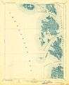 1903 topographic map.
References
- Merriam-Webster's Geographical Dictionary, Third Edition. Springfield, Massachusetts: Merriam-Webster Incorporated, 1997. ISBN 0-87779-546-0.
- ↑ Merriam-Webster's Geographical Dictionary, Third Edition, p. 150.
- ↑ Blake, Jr., Jerrell. "National Register of Historic Places (NRHP) Registration Form, Bloodsworth Island Archaeological District". The Digital Archaeological Record. Retrieved 19 September 2016.
- ↑ "Bloodsworth Island Range". United States Navy. Retrieved 19 September 2016.
This article is issued from
Wikipedia.
The text is licensed under Creative Commons - Attribution - Sharealike.
Additional terms may apply for the media files.