Blokland, Utrecht
| Blokland | |
|---|---|
| Hamlet | |
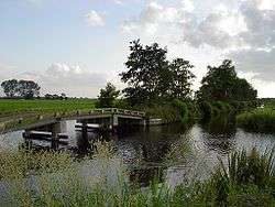 The Bloklandse Dijk | |
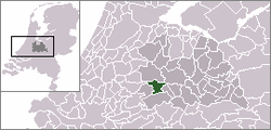 | |
 Blokland in the municipality of Montfoort. | |
| Coordinates: 52°1′47″N 4°57′37″E / 52.02972°N 4.96028°ECoordinates: 52°1′47″N 4°57′37″E / 52.02972°N 4.96028°E | |
| Country | Netherlands |
| Province | Utrecht (province) |
| Municipality | Montfoort |
| Population (2006) | |
| • Total | 160 |
| Time zone | UTC+1 (CET) |
| • Summer (DST) | UTC+2 (CEST) |
Blokland is a hamlet in the Dutch province of Utrecht. It is a part of the municipality of Montfoort, and lies about 1 km southeast of that city, and 6 km west of IJsselstein.[1] Blokland has a population of around 160.[2]
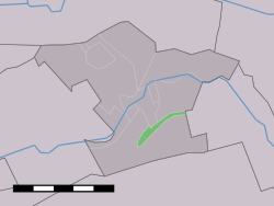
Blokland was a heerlijkheid (manor), covering the entire polder "Blokland", which is the area south of the Bloklandse Dijk.[3]
When the current municipal system was introduced in the Netherlands in 1812, Blokland became part of the municipality Montfoort for a short while. It was part of the municipality of Willeskop between 1818 and 1989, when that municipality was merged with Montfoort.
References
- ↑ ANWB Topografische Atlas Nederland, Topografische Dienst and ANWB, 2005.
- ↑ Statistics Netherlands, 2007. Figures are for the year 2006. Statistics are available in Google Earth format. Statistical area "Blokland".
- ↑ Abraham Jacob van der Aa, "Aardrijkskundig woordenboek der Nederlanden", vol. 1 (A), 1839.
This article is issued from
Wikipedia.
The text is licensed under Creative Commons - Attribution - Sharealike.
Additional terms may apply for the media files.