Bleicherode
| Bleicherode | ||
|---|---|---|
| ||
 Bleicherode Location of Bleicherode within Nordhausen district  | ||
| Coordinates: 51°25′0″N 10°34′0″E / 51.41667°N 10.56667°ECoordinates: 51°25′0″N 10°34′0″E / 51.41667°N 10.56667°E | ||
| Country | Germany | |
| State | Thuringia | |
| District | Nordhausen | |
| Government | ||
| • Mayor | Frank Rostek (CDU) | |
| Area | ||
| • Total | 28.27 km2 (10.92 sq mi) | |
| Elevation | 237 m (778 ft) | |
| Population (2017-12-31)[1] | ||
| • Total | 6,134 | |
| • Density | 220/km2 (560/sq mi) | |
| Time zone | CET/CEST (UTC+1/+2) | |
| Postal codes | 99752 | |
| Dialling codes | 036338 | |
| Vehicle registration | NDH | |
| Website | www.bleicherode.de | |

Bleicherode is a town in the district of Nordhausen, in Thuringia, Germany. It is situated on the river Wipper, 17 km southwest of Nordhausen. On 1 December 2007, the former municipality Obergebra was incorporated by Bleicherode. Every Thursday, there is a market held in the town.
Historically, Bleicherode belonged to the Prussian province of Saxony between 1700 and 1945.
One of Bleicherode's most famous natives is the cartographer August Heinrich Petermann.
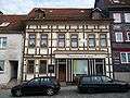 The house where Petermann was born: Neue Straße 3, Bleicherode
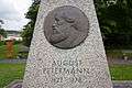 Memorial for August Petermann in Bleicherode
Notable persons
- August Heinrich Petermann (1822–1878), German cartographer
- Adalbert Merx (1838–1909), German theologian
- Hans Beyth (1901–1947), German-Jewish banker and Zionist (leader of Youth Aliyah, 1945-47)
See also
- Gerson von Bleichröder (1822–1893), German-Jewish banker, Chief banker of Otto von Bismarck
References
| Authority control |
|---|
This article is issued from
Wikipedia.
The text is licensed under Creative Commons - Attribution - Sharealike.
Additional terms may apply for the media files.