Blanchard, Louisiana
| Blanchard, Louisiana | |
|---|---|
| Town | |
| Motto(s): "Reach out and grab your future...It's all in Blanchard"[1] | |
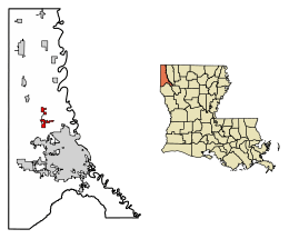 Location of Blanchard in Caddo Parish, Louisiana. | |
.svg.png) Location of Louisiana in the United States | |
| Coordinates: 32°35′12″N 93°53′15″W / 32.58667°N 93.88750°WCoordinates: 32°35′12″N 93°53′15″W / 32.58667°N 93.88750°W | |
| Country | United States |
| State | Louisiana |
| Parish | Caddo |
| Area[2] | |
| • Total | 4.00 sq mi (10.37 km2) |
| • Land | 4.00 sq mi (10.37 km2) |
| • Water | 0.00 sq mi (0.00 km2) |
| Elevation | 223 ft (68 m) |
| Population (2010) | |
| • Total | 2,899 |
| • Estimate (2016)[3] | 3,144 |
| • Density | 785.21/sq mi (303.16/km2) |
| Time zone | UTC-6 (CST) |
| • Summer (DST) | UTC-5 (CDT) |
| Area code(s) | 318 |
| FIPS code | 22-07730 |
| Website |
www |
Blanchard is a town in Caddo Parish, Louisiana, United States. The population was 2,899 at the 2010 census.[4] It is part of the Shreveport–Bossier City Metropolitan Statistical Area.
History
Blanchard was likely named for Newton C. Blanchard, a United States Representative, Senator, and the 33rd Governor of Louisiana.[5]
Geography
Blanchard is located at 32°35′12″N 93°53′15″W / 32.58667°N 93.88750°W (32.586762, -93.887590).[6] Louisiana Highway 173 passes through the town as Main Street. Downtown Shreveport is 10 miles (16 km) to the southeast.
According to the United States Census Bureau, the town has a total area of 4.0 square miles (10.3 km2), all land.[4]
Demographics
| Historical population | |||
|---|---|---|---|
| Census | Pop. | %± | |
| 1970 | 806 | — | |
| 1980 | 1,128 | 40.0% | |
| 1990 | 1,175 | 4.2% | |
| 2000 | 2,050 | 74.5% | |
| 2010 | 2,899 | 41.4% | |
| Est. 2016 | 3,144 | [3] | 8.5% |
| U.S. Decennial Census[7] | |||
As of the census[8] of 2000, there were 2,682 people, 787 households, and 602 families residing in the town. The population density was 849.0 people per square mile (328.4/km²). There were 813 housing units at an average density of 336.7 per square mile (130.2/km²). The racial makeup of the town was 95.32% White, 2.93% African American, 0.54% Native American, 0.39% Asian, 0.10% Pacific Islander, 0.10% from other races, and 0.63% from two or more races. Hispanic or Latino of any race were 0.59% of the population.
There were 787 households out of which 37.0% had children under the age of 18 living with them, 65.8% were married couples living together, 7.9% had a female householder with no husband present, and 23.4% were non-families. 21.5% of all households were made up of individuals and 13.7% had someone living alone who was 65 years of age or older. The average household size was 2.60 and the average family size was 3.02.
26.8% of the population is under the age of 18, 6.9% are ages 18 to 24, 28.0% are ages 25 to 44, 23.8% are ages 45 to 64, and 14.6% are 65 years of age or older. The median age is 38 years. For every 100 females, there were 93.4 males. For every 100 females age 18 and over, there were 86.2 males.
The median income for a household in the town was $44,750, and the median income for a family was $58,047. Males had a median income of $41,161 versus $26,161 for females. The per capita income for the town was $22,391. About 2.8% of families and 5.2% of the population were below the poverty line, including 3.1% of those under age 18 and 13.7% of those age 65 or over.
Notable people
- Elle Evans, former Miss Teen Louisiana 2008; "Miss October 2009" Playmate for Playboy
- Hal Sutton, professional golfer
- Ollie Tyler, former Caddo Parish school superintendent and interim Louisiana State Education Superintendent; Shreveport mayor, born in Blanchard in 1945
References
- ↑ "Town of Blanchard, Louisiana". Town of Blanchard, Louisiana. Retrieved August 26, 2012.
- ↑ "2016 U.S. Gazetteer Files". United States Census Bureau. Retrieved Jul 2, 2017.
- 1 2 "Population and Housing Unit Estimates". Retrieved June 9, 2017.
- 1 2 "Geographic Identifiers: 2010 Demographic Profile Data (G001): Blanchard town, Louisiana". U.S. Census Bureau, American Factfinder. Retrieved August 13, 2014.
- ↑ Leeper, Clare D'Artois (19 October 2012). Louisiana Place Names: Popular, Unusual, and Forgotten Stories of Towns, Cities, Plantations, Bayous, and Even Some Cemeteries. LSU Press. p. 41. ISBN 978-0-8071-4740-5.
- ↑ "US Gazetteer files: 2010, 2000, and 1990". United States Census Bureau. 2011-02-12. Retrieved 2011-04-23.
- ↑ "Census of Population and Housing". Census.gov. Archived from the original on May 12, 2015. Retrieved June 4, 2015.
- ↑ "American FactFinder". United States Census Bureau. Archived from the original on 2013-09-11. Retrieved 2008-01-31.
External links
City of Shreveport & Shreveport/Bossier City Metro | ||
|---|---|---|
| Topics | ||
| Shreveport neighborhoods |
| |
| The Ark-La-Tex | ||
Municipalities and communities of Caddo Parish, Louisiana, United States | ||
|---|---|---|
| Cities | 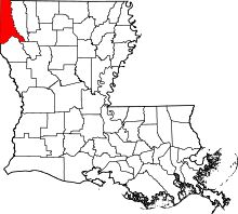 | |
| Towns | ||
| Villages | ||
| CDP | ||
| Other unincorporated communities | ||
| Ghost town | ||
| Footnotes | ‡This populated place also has portions in an adjacent parish or parishes | |