Blackfoot Mountain
| Blackfoot Mountain | |
|---|---|
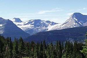 Blackfoot Mountain is along the skyline in the background on the left beyond Blackfoot Glacier | |
| Highest point | |
| Elevation | 9,579 ft (2,920 m) [1] NAVD 88 |
| Prominence | 1,721 ft (525 m) [1] |
| Parent peak | Mount Jackson[1] |
| Listing | Mountains in Flathead County, Montana |
| Coordinates | 48°34′55″N 113°40′06″W / 48.58194°N 113.66833°WCoordinates: 48°34′55″N 113°40′06″W / 48.58194°N 113.66833°W [2] |
| Geography | |
 Blackfoot Mountain | |
| Parent range | Lewis Range |
| Topo map | USGS Mount Jackson |
| Climbing | |
| First ascent | 1894 Henry L. Stimson[1] |
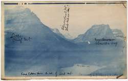
Little Chief Mountain, Blackfoot Mountain, and Citadel Mountain, viewed from Goat Mountain
Blackfoot Mountain (9,579 ft (2,920 m)) is located in the Lewis Range, Glacier National Park in the U.S. state of Montana.[3] To the north of Blackfoot Mountain lies Blackfoot Glacier, one of the largest glaciers in the park. The stagnant Pumpelly Glacier is located to the immediate east and northeast of the mountain.
See also
References
- 1 2 3 4 "Blackfoot Mountain, Montana". Peakbagger.com. Retrieved June 4, 2018.
- ↑ "Blackfoot Mountain". Geographic Names Information System. United States Geological Survey. Retrieved June 4, 2018.
- ↑ Mount Jackson, MT (Map). TopoQwest (United States Geological Survey Maps). Retrieved June 4, 2018.
This article is issued from
Wikipedia.
The text is licensed under Creative Commons - Attribution - Sharealike.
Additional terms may apply for the media files.