Black River (Ohio)
| Black River | |
|---|---|
 | |
| Country | United States of America |
| Physical characteristics | |
| Main source | Elyria, Ohio, at confluence of East and West Branches, or northern Ashland County, Ohio for West Branch |
| River mouth | Lake Erie in Lorain, Ohio |
| Length | 12 miles (19 km), or about 42 miles (68 km) including West Branch |
| Basin features | |
| Basin size | 470 sq mi (1,200 km2) |
The Black River[2] is a tributary of Lake Erie, about 12 mi (19 km) long, in northern Ohio in the United States.[3] Via Lake Erie, the Niagara River and Lake Ontario, it is part of the watershed of the St. Lawrence River, which flows to the Atlantic Ocean. The Black drains an area of 470 mi² (1217 km²).[4]
According to the Geographic Names Information System, the Black River was formerly named "Canesadooharie River" and "Riviere en Grys."[5] (These two historical names were actually originally intended to refer to nearby rivers, instead of the Black River.[6])
Course
The Black River is formed in the city of Elyria by the confluence of its east and west branches:
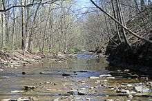
- The East Branch Black River[7] is formed in northwestern Medina County by the confluence of two short tributaries, the East Fork Black River[8] and the West Fork East Branch Black River.[9] The East Fork flows southwardly past Lodi before turning northwestwardly, and the West Fork rises in northeastern Ashland County and flows generally eastwardly into Medina County; the two join about 1 mi (2 km) northwest of Lodi, and the East Branch then flows generally northwardly into Lorain County, past Grafton.[10] It drains an area of 222 mi² (575 km²).[4]
- The West Branch Black River,[11] about 30 mi (48 km) long,[3] rises in northern Ashland County and flows generally northeastwardly into Lorain County, past Rochester.[10] It drains an area of 174 mi² (451 km²).[4]
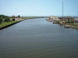
From the confluence of the branches in Elyria, the Black River flows generally northwardly past Sheffield into the city of Lorain, where it enters Lake Erie at 41°28′20″N 82°10′58″W / 41.472131°N 82.182886°W.[10] The mouth of the river forms part of the harbor of Lorain.[3]
Name and History
- In the 1700s, the Black River was known as the "Reneshoua River", and was also referred to as "la Riviere de la Cuiliere' by early French and British explorers. The origin of those names is uncertain, although "Cuilliere" was also the name of a French fur-trader who frequented the Lake Erie shore areas about 1760. This river became well known by the early European explorers, as being the safest harboring spot at the western end of "the cliffs" which extended many miles along the southern Lake Erie shore from this river almost to the Cuyahoga River's mouth, and in the 1700s these cliffs had almost no beach areas for landing even a small boat, and were too high and steep to climb.
 Reneshoua River in 1778
 - In 1787, the Moravian missionary, David Zeisberger, led a group of Christian-converted Native-Americans from their settlement on the Cuyahoga River, to a new intended settlement probably on the Black River*, about 5 or 6 miles upstream from Lake Erie. However, after remaining only twelve days, the group was prevented from settling here due to warnings by a local Native-American tribe ( about potential dangers from the inevitable "white" settlers), and so the group instead relocated to the Huron River, in (now) Milan, Ohio. (*-Zeisberger did not specifically record the name of the river of their brief stay, but merely that it was "halfway between" the Cuyahoga and Huron Rivers.)
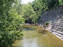
- The Black River has two impressive falls, in the city of Elyria Ohio; these falls having been the reason that 19th-century historians falsely attributed the Black River as being the "Canesadooharie", the river upon which James Smith encamped with Native-Americans, in 1756. However, the river that Smith had actually referred to as the "Canesadooharie", was instead the Huron River; its Native-American name was also phonetically interpreted by other European explorers to be the "Guahadahuri". The only original-source for the word "Canesadooharie" was Col. James Smith (captured by Native-Americans and brought to live among them near Sandusky Bay) who had written about his visit to the "falls" on the river "Canesadooharie". Therefore, the 19th-century historians theorized that the falls of which Smith spoke, might have been the same falls in the (now) city of Elyria, Ohio. Subsequently, other historians surmised that the very word "Canesadooharie" must translate to "black pearl", or even more romantically as "string of black pearls", therefore proving conclusively, in their minds, that the "Canesadooharie" must be the Black River. Those old theories therefore eventually became 'fact'; but unfortunately they were not accurate. The single "falls" of which James Smith wrote, he specifically describes as "12 to 15 feet high, and nearly perpendicular". However, neither of the two individual falls near the City of Elyria, are nearly that diminutive in drop, nor would they be described as "nearly" perpendicular; both are about 40 feet in height, and absolutely perpendicular. These two Black River falls are very near each other, within easy walking distance, and any person spending several weeks fishing and hunting in any area, as Smith says he did, would not have overlooked the other falls here. Smith also specifically stated that the "Canesadooharie" was "about 8 miles east of Sandusky" (the Huron River is indeed about 10 miles east of Sandusky Bay's mouth), and "interlocks with the West Branch of the Muskingum" (this refers to the Black Fork of the Mohican River, which connects into the Muskingum). But even recent historians choose to completely dismiss these other detailed descriptions of Smith's own travels here. The likelihood is that the single falls which Smith experienced over a many week period, "12 to 15 feet high, and nearly perpendicular", i.e. high and very steep rapids, was somewhere in the vicinity of (now) Milan, Ohio, but time and nature quickly altered them beyond recognition, even by the mid-1800s. But the beautiful twin falls of the Black River, are still worth a visit even today, even if they weren't visited by James Smith in 1756. [sources: Indian Captivities (pp. 191–201) by Drake (publ.1852, Derby and Miller); The Wilderness Trail (p. 338) by Hanna (publ.1911 by Knickerbocker, NY); Diary(1787–1791) of David Zeisberger, (publ.1885 by Robert Clarke and Co., Cinti.); History of Lorain County, Williams 1879]
- "Riviere en Grys" (another GNIS[5] name for the Black River) was instead originally the name of now Beaver Creek, several miles west of the Black River.[12]
See also
| Wikimedia Commons has media related to Black River (Ohio). |
References
- ↑ Black River Reservation website from Lorain County Metroparks Archived August 13, 2006, at the Wayback Machine.
- ↑ United States Geological Survey Hydrological Unit Code: 04-11-00-01-
- 1 2 3 Columbia Gazetteer of North America entry Archived March 12, 2007, at the Wayback Machine.
- 1 2 3 Map of Ohio watersheds Archived March 11, 2007, at the Wayback Machine.
- 1 2 U.S. Geological Survey Geographic Names Information System: Black River
- ↑ The Wilderness Trail; Hanna (publ.1911 by Knickerbocker, NY)
- ↑ U.S. Geological Survey Geographic Names Information System: East Branch Black River
- ↑ U.S. Geological Survey Geographic Names Information System: East Fork Black River
- ↑ U.S. Geological Survey Geographic Names Information System: West Fork East Branch Black River
- 1 2 3 DeLorme (1991). Ohio Atlas & Gazetteer. Yarmouth, Maine: DeLorme. ISBN 0-89933-233-1
- ↑ U.S. Geological Survey Geographic Names Information System: West Branch Black River
- ↑ Hutchins, Thos.; map, 1778