Black Canyon Lake (Arizona)
| Black Canyon Lake | |
|---|---|
| Location |
Navajo County, Arizona United States |
| Coordinates | 34°19′50″N 110°42′1″W / 34.33056°N 110.70028°WCoordinates: 34°19′50″N 110°42′1″W / 34.33056°N 110.70028°W |
| Type | Reservoir |
| Primary inflows | Snowpack |
| Primary outflows | West Fork Black Canyon |
| Basin countries | United States |
| Surface area | 78 acres (32 ha)[1][2] |
| Average depth | 35 ft (11 m)[1][2] |
| Max. depth | 60 ft (18 m)[1][2] |
| Surface elevation | 7,060 ft (2,150 m)[1][3] |
Black Canyon Lake is a lake in Navajo County, Arizona, United States.[3]
Description
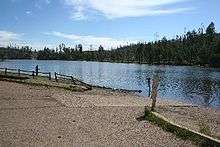
The lake was built along the Mogollon Rim in 1964 by the Arizona Game and Fish Department to provide water recreation opportunities for the public. Despite being affected by the 2002 Rodeo-Chediski Fire, Black Canyon Lake remains a popular and beautiful spot for picnics, camping and fishing. Because of the fire, the entire area around Black Canyon Lake is open for day use only due to the danger of falling trees. The facilities are maintained by Apache-Sitgreaves National Forests division of the USDA Forest Service.[2]
Black Canyon Lake has 78 acres (32 ha), with a maximum depth of 60 feet (18 m) and an average depth of 35 feet (11 m).[1] Like other Rim lakes, Black Canyon is deep, and historically has been low in nutrients. Because of nutrients from the fire and ash, Black Canyon Lake is now managed as a put-and-grow fishery. The Department stocks fingerlings, sub-catchable and catchable-sized rainbow trout in the spring and early summer, with additional catchables stocked in the fall. Although some trees around the lake are charred, the perimeter of the lake is forested and scenic.[2]
Location
Situated at 7,060 feet (2,150 m), the lake is located 18 miles (29 km) southwest of Heber in the Apache-Sitgreaves National Forests.[1] To access, turn south on Forest Road 300 from State Route 260. Drive 2.4 miles (3.9 km) and turn east, or left, on Forest Road 86. Drive 3 miles (4.8 km) further to the lake turnoff. Access is restricted in the winter when roads are closed due to snow, generally December to early April.[2]
Fish species
References
Sources
- Information and Education Division (2007), Arizona Fishin' Holes, Phoenix, AZ: Arizona Game and Fish Department
Footnotes
- 1 2 3 4 5 6 7 8 9 10 "Middle Little Colorado River Sub-Watershed" (PDF). fws.gov. U.S. Fish and Wildlife Service & Arizona Game and Fish Department. Retrieved 31 Dec 2013.
- 1 2 3 4 5 6 "Black Canyon Lake" (PDF). azgfd.gov. Arizona Game and Fish Department. Nov 2011. Retrieved 2 Jan 2016.
- 1 2 U.S. Geological Survey Geographic Names Information System: Black Canyon Lake (Arizona)
External links
| Wikimedia Commons has media related to Black Canyon Lake (Arizona). |