Black Butte Lake
| Black Butte Lake | |
|---|---|
 Black Butte Dam and Lake | |
| Location | Glenn / Tehama counties, California, United States |
| Coordinates | 39°48′21″N 122°21′28″W / 39.80583°N 122.35778°WCoordinates: 39°48′21″N 122°21′28″W / 39.80583°N 122.35778°W |
| Type | reservoir |
| Primary inflows | Stony Creek |
| Primary outflows | Stony Creek[1] |
| Catchment area | 741 square miles (1,920 km2)[1] |
| Basin countries | United States |
| Max. length | 7 mi (11.3 km) |
| Surface area | 4,460 acres (1,800 ha)[1] |
| Water volume | 143,700 acre feet (177,300,000 m3)[1] |
| Shore length1 | 40 miles (64 km) |
| Surface elevation | 512 feet (156 m)[2] |
| 1 Shore length is not a well-defined measure. | |
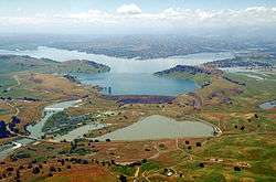
Black Butte Lake is an artificial lake located in Tehama and Glenn counties in the U.S. state of California.[2] The lake was formed from Stony Creek in 1963 upon the completion of Black Butte Dam[1] by the U.S. Army Corps of Engineers. The dam is located approximately 9 miles (14.5 km) west of Orland. At full pool, the lake is 7 miles (11.3 km) long and has a shoreline of 40 miles (64.4 km) and a surface area of 4,460 acres (18 km2). The dam and lake were constructed for flood protection for local towns and agricultural lands.
The California Office of Environmental Health Hazard Assessment released a warning regarding eating fish caught from this lake based on the elevated mercury level.[3]
See also
References
- 1 2 3 4 5 "Dams Owned and Operated by Federal Agencies" (PDF). California Department of Water Resources, Division of Safety of Dams. Archived from the original (PDF) on October 5, 2012. Retrieved October 31, 2012.
- 1 2 "Black Butte Lake". Geographic Names Information System. United States Geological Survey.
- ↑ Admin, OEHHA (2014-12-30). "Black Butte Lake". OEHHA. Retrieved 2018-06-11.
External links
This article is issued from
Wikipedia.
The text is licensed under Creative Commons - Attribution - Sharealike.
Additional terms may apply for the media files.