Black Butte (Siskiyou County, California)
| Black Butte | |
|---|---|
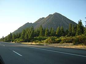 Black Butte from I-5 | |
| Highest point | |
| Elevation | 6,334 ft (1,931 m) NAVD 88[1] |
| Coordinates | 41°21′59″N 122°20′53″W / 41.36634515°N 122.347982333°WCoordinates: 41°21′59″N 122°20′53″W / 41.36634515°N 122.347982333°W [1] |
| Geography | |
| Location | Siskiyou County, California, U.S. |
| Parent range | Cascades |
| Topo map | USGS City of Mount Shasta |
| Geology | |
| Age of rock | Holocene[2] |
| Mountain type | Lava dome[2] |
| Volcanic arc | Cascade Volcanic Arc[3] |
| Last eruption | About 9,500 years ago[2] |
| Climbing | |
| Easiest route | Trail[4] |

Black Butte is a cluster of overlapping dacite lava domes in a butte,[2] a parasitic cone of Mount Shasta.[5] It is located directly adjacent to Interstate 5 at milepost 742 between the city of Mount Shasta and Weed, California. The highway crosses a 3,912 ft (1,192 m) pass, Black Butte Summit, at the western base of the lava domes. The lava domes were extruded at the foot of the cone of Shastina following the period of its major eruptions about 9,000–10,000 years ago.[2]
A United States Forest Service fire lookout tower was built on the summit in the 1930s, but destroyed during the Columbus Day Storm of 1962. A new lookout was built in 1963 and operated until 1973. The building was moved by helicopter to a new location in 1975 and only the concrete foundation remains today. A 2.5-mile-long (4.0 km) trail leads to the summit from a trailhead accessible by dirt roads off the Everitt Memorial Highway.[6] The summit boasts an outstanding view of the southwest side of Shasta and Shastina, and on clear days Mount McLoughlin is easily visible 70 miles (113 km) to the north in Oregon.[7]
See also
References
- 1 2 "Black Butte". NGS data sheet. U.S. National Geodetic Survey. Retrieved 2009-08-06.
- 1 2 3 4 5 Miller, C. Dan (1980). "Potential Hazards from Future Eruptions in the Vicinity of Mount Shasta Volcano, Northern California: USGS Bulletin 1503". United States Geological Survey. Archived from the original on May 3, 2007.
- ↑ "Shasta". Global Volcanism Program. Smithsonian Institution. Retrieved 2009-01-05.
- ↑ Selters, Andy; Michael Zanger (2006). Mt. Shasta Book: Guide to Hiking, Climbing, Skiing & Exploring the Mountain & Surrounding Area (3rd ed.). Wilderness Press. p. 42. ISBN 978-0-89997-404-0.
- ↑ Wood, Charles A.; Jürgen Kienle, eds. (1990). Volcanoes of North America. Cambridge University Press. pp. 214–216. ISBN 0-521-43811-X.
- ↑ "Black Butte (CA)". SummitPost.org. Retrieved 2009-12-14.
- ↑ "Shasta-Trinity National Forest: Black Butte Trail". USDA Forest Service.
Further reading
- English, Jane; Bonnie Eddy, eds. (2004). Mount Shasta's Black Butte. Earth Heart. ISBN 0-934747-09-1.
- Harris, Stephen L. (2005). Fire Mountains of the West: The Cascade and Mono Lake Volcanoes (3rd ed.). Mountain Press Publishing Company. ISBN 0-87842-511-X.
- Selters, Andy; MIchael Zanger (2006). The Mt. Shasta Book (3rd ed.). Wilderness Press. ISBN 0-89997-404-X.
External links
- "Black Butte". Geographic Names Information System. United States Geological Survey. Retrieved 2009-12-14.
| Wikimedia Commons has media related to Black Butte (Siskiyou County, California). |