Bjärtrå
| Bjärtrå | ||
|---|---|---|
| Parish | ||
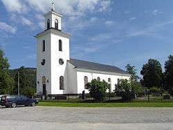 Bjärtrå parish church | ||
| ||
| Coordinates: 62°59′N 17°52′E / 62.983°N 17.867°ECoordinates: 62°59′N 17°52′E / 62.983°N 17.867°E | ||
| Country | Sweden | |
| County | Västernorrland County | |
| Area | ||
| • Total | 158 km2 (61 sq mi) | |
| Population | ||
| • Total | 1,687 | |
| • Density | 11/km2 (28/sq mi) | |
| Time zone | UTC+1 (CET) | |
| • Summer (DST) | UTC+2 (CEST) | |
| Province | Ångermanland | |
| Municipal code | 2282 | |
| Climate | Dfc | |

Bjärtrå is a parish of the province of Ångermanland in Sweden. Since 1974 it has been administered as part of the Kramfors Municipality.
The parish has an area of 158 square kilometres, and in the year 2000 there were 1,687 inhabitants. The locality of Lugnvik and parts of Sandslån, Klockestrand, and Strinne, lie within Bjärtrå.[1]
The parish was established in the Middle Ages. In 1862 the rural district of Bjärtrå was created. In 1974 this was merged into the municipality of Kramfors.[1]
Round Barn
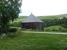
The Bjärtrå Round Barn
The Bjärtrå round barn (pictured) is a wooden building believed to have been constructed about 1848. In 1958 it was bought by a history society, which continues to maintain it.
Notes
This article is issued from
Wikipedia.
The text is licensed under Creative Commons - Attribution - Sharealike.
Additional terms may apply for the media files.