Bivalve, Maryland
| Bivalve | |
|---|---|
| Census-designated place | |
 Bivalve Location within the state of Maryland  Bivalve Bivalve (the US) | |
| Coordinates: 38°18′22″N 75°53′21″W / 38.30611°N 75.88917°WCoordinates: 38°18′22″N 75°53′21″W / 38.30611°N 75.88917°W | |
| Country | United States |
| State | Maryland |
| County | Wicomico |
| Area[1] | |
| • Total | 1.349 sq mi (3.49 km2) |
| • Land | 1.312 sq mi (3.40 km2) |
| • Water | 0.037 sq mi (0.10 km2) |
| Elevation | 13 ft (4 m) |
| Population (2010)[2] | |
| • Total | 201 |
| • Density | 150/sq mi (58/km2) |
| Time zone | UTC−5 (Eastern (EST)) |
| • Summer (DST) | UTC−4 (EDT) |
| ZIP code | 21814 |
| Area code(s) | 410 & 443 |
| GNIS feature ID | 589760[3] |
Bivalve is an unincorporated community and census-designated place along the eastern shore of the lower Nanticoke River, near its mouth on the Chesapeake Bay, in Wicomico County, Maryland, United States. Its population was 201 as of the 2010 census.[2] Bivalve takes its name from the oyster, upon which the town's economy once depended. It is part of the Salisbury, Maryland-Delaware Metropolitan Statistical Area.
The Yellow Brick House was listed on the National Register of Historic Places in 1978.[4]
References
- ↑ "US Gazetteer files: 2010, 2000, and 1990". United States Census Bureau. 2011-02-12. Retrieved 2011-04-23.
- 1 2 "American FactFinder". United States Census Bureau. Archived from the original on 2013-09-11. Retrieved 2011-05-14.
- ↑ "Bivalve". Geographic Names Information System. United States Geological Survey.
- ↑ National Park Service (2010-07-09). "National Register Information System". National Register of Historic Places. National Park Service.
External links
Municipalities and communities of Wicomico County, Maryland, United States | ||
|---|---|---|
| Cities | 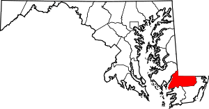 | |
| Towns | ||
| CDPs | ||
| Unincorporated communities | ||
| Footnotes | ‡This populated place also has portions in an adjacent county or counties | |
This article is issued from
Wikipedia.
The text is licensed under Creative Commons - Attribution - Sharealike.
Additional terms may apply for the media files.