Jägerhorn
| Jägerhorn | |
|---|---|
 | |
| Highest point | |
| Elevation | 3,970 m (13,020 ft) |
| Prominence | 58 m (190 ft) [1] |
| Parent peak | Monte Rosa |
| Coordinates | 45°57′8.2″N 7°52′37.9″E / 45.952278°N 7.877194°ECoordinates: 45°57′8.2″N 7°52′37.9″E / 45.952278°N 7.877194°E |
| Geography | |
 Jägerhorn Location in the Alps | |
| Location |
Valais, Switzerland Piedmont, Italy |
| Parent range | Pennine Alps |
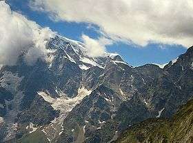
The Jägerhorn is a mountain of the Pennine Alps, located on the border between Switzerland and Italy. It lies just north of Monte Rosa, at a height of 3,970 metres above sea level, and overlooks the village of Macugnaga on its east side (in the Italian region of Piedmont), 2,600 metres below. On its west side it overlooks the Gorner Glacier (Swiss canton of Valais).
Near the summit (3,960 m) is located a small mountain hut, the Bivacco Città di Gallarate. It is owned by the Italian Alpine Club.
References
External links
This article is issued from
Wikipedia.
The text is licensed under Creative Commons - Attribution - Sharealike.
Additional terms may apply for the media files.