Bishopscourt, Isle of Man
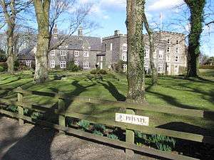
Bishopscourt (previously known as Ballacurry, in Manx: the farm of McCurry or O'Curry),[1] consists of a 17th century mansion house, the St Nicholas (Private Chapel) in the Church of England Diocese of Sodor & Man, and the former estate of Ballachurry or Bishopscourt Manse. Previously the official residence of the Bishop of Sodor and Man, the current Bishopscourt House and estate are now in private ownership.
Bishopscourt is situated north of Kirk Michael on the primary A3 Castletown to Ramsey road and is known as a historic point in the TT races, adjacent to the 16th Milestone road-side marker of the Snaefell Mountain Course close to the tertiary C19 Orrisdale Loop Road junction. The Bishopscourt Manse and the Bishop's Glen form part of the boundary of the parishes of Michael and Ballaugh.
Description
The current residence dates from the 17th century; the former moated King Orry's Tower and previous timbered residence was rebuilt by Bishop Thomas Wilson from 1698 after finding the 'house in ruins nothing but a sentient tower and chapel remaining entire'. Bishop Wilson rebuilt in the present castellated baronial style, and it was enlarged by Bishop Claudius Crigan from 1784 onwards. The King Orry's Tower was repaired and restored by Bishop Crigan in preparation 'to reside at Bishopscourt, to repair and even rebuild the ruins of which as all was ruins has cost a very severe expense'.[2] The chapel dating from 1651 adjacent to King Orry's Tower was demolished around 1815 and replaced by a Georgian Chapel on the same site, which itself was replaced by a Victorian Gothic Chapel of St. Nicholas on a slightly different site by Bishop Horatio Powys.[3] Further renovation occurred after a fire in 1893 destroyed the hall section of Bishopscourt house.[4]
Sources
- ↑ Place Names of the Isle of Man by John Kneen MA pp446 (1970) Yn Cheshaght Ghailckagh The Scolar Press
- ↑ Athol Papers 117-10
- ↑ An Illustrated Encyclopedia of the Isle of Man by David T.Webber Revised by Frank Cowin and F.J.Radcliffe pp 22 (1997) The Manx Experience ISBN 1-873120-25-7
- ↑ The Fort at Bishopscourt, Isle of Man by R A Curphy page 8 Medieval Archaeology