Bishops Cap
| Bishops Cap | |
|---|---|
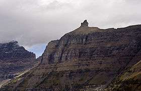 Bishops Cap along the Garden Wall | |
| Highest point | |
| Elevation | 9,127 ft (2,782 m) [1] |
| Prominence | 327 ft (100 m) [1] |
| Coordinates | 48°43′29″N 113°42′33″W / 48.72472°N 113.70917°WCoordinates: 48°43′29″N 113°42′33″W / 48.72472°N 113.70917°W [2] |
| Geography | |
 Bishops Cap | |
| Parent range | Lewis Range |
| Topo map | USGS Logan Pass, MT |
Bishops Cap (9,127 feet (2,782 m)) is located in the Lewis Range, Glacier National Park in the U.S. state of Montana.[3] Located above the Garden Wall and straddling the Continental Divide, when viewed from the south at Logan Pass, the peak appears to resemble a Bishop's headwear. The name Bishops Cap is descriptive only, and there's no known origin.[4]
See also
References
- 1 2 "Bishops Cap, Montana". Peakbagger.com. Retrieved June 4, 2018.
- ↑ "Bishops Cap". Geographic Names Information System. United States Geological Survey. Retrieved June 4, 2018.
- ↑ Logan Pass, MT (Map). TopoQwest (United States Geological Survey Maps). Retrieved June 4, 2018.
- ↑ Holterman, Jack (2006). Place Names of Glacier National Park. Helena, MT: Riverbend Publishing. p. 34. ISBN 1-931832-68-4.
This article is issued from
Wikipedia.
The text is licensed under Creative Commons - Attribution - Sharealike.
Additional terms may apply for the media files.