Bishop Pass
| Bishop Pass | |
|---|---|
 Bishop Pass Trail | |
| Elevation | 11,972 ft (3,649 m) |
| Traversed by | Bishop Pass Trail |
| Location | Inyo and Fresno Counties, California |
| Range | Sierra Nevada |
| Coordinates | 37°06′53″N 118°32′41″W / 37.11472°N 118.54472°W[1] |
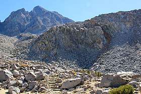
Bishop Pass, 11,972 ft (3,649 m),[1] is a high mountain pass in the southern Sierra Nevada, California, on the border of the Inyo National Forest (John Muir Wilderness) on the north and Kings Canyon National Park on the south. The Bishop Pass Trail goes over the pass, connecting the Bishop Creek valley in the north (accessed via South Lake Road off Highway 168 with the John Muir Trail/Pacific Crest Trail in the south. The pass is located just to the west of Mount Agassiz and is surrounded by many alpine lakes in the Dusy Basin and the Bishop Lake basin.[2]
References
- 1 2 "Bishop Pass". Geographic Names Information System. United States Geological Survey. 1981-01-19. Retrieved 2017-09-20.
- ↑ "Bishop Pass Trail - South Lake". U.S. Forest Service. Retrieved 2017-09-20.
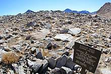
Trail sign at Bishop Pass
This article is issued from
Wikipedia.
The text is licensed under Creative Commons - Attribution - Sharealike.
Additional terms may apply for the media files.