Bisbee Douglas International Airport
| Bisbee Douglas International Airport | |||||||||||||||
|---|---|---|---|---|---|---|---|---|---|---|---|---|---|---|---|
| Summary | |||||||||||||||
| Airport type | Public | ||||||||||||||
| Owner | Cochise County | ||||||||||||||
| Serves | Douglas & Bisbee, Arizona | ||||||||||||||
| Elevation AMSL | 4,154 ft / 1,266 m | ||||||||||||||
| Coordinates | 31°28′08″N 109°36′13″W / 31.46889°N 109.60361°WCoordinates: 31°28′08″N 109°36′13″W / 31.46889°N 109.60361°W | ||||||||||||||
| Map | |||||||||||||||
 DUG  DUG | |||||||||||||||
| Runways | |||||||||||||||
| |||||||||||||||
| Statistics (2009) | |||||||||||||||
| |||||||||||||||
Bisbee Douglas International Airport (IATA: DUG, ICAO: KDUG, FAA LID: DUG) is a county-owned airport 9 miles (7.8 nmi; 14 km) northwest of Douglas[1] and 17 miles (15 nmi; 27 km) east of Bisbee, both in Cochise County, Arizona.[1] The FAA's National Plan of Integrated Airport Systems for 2009–2013 categorizes it as a general aviation facility.[2]
History
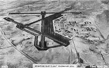
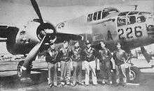
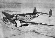
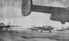
World War II
In addition to Douglas Army Airfield, five auxiliary airfields were constructed in the area for emergency and overflow use:
- McNeal Field (Aux #1) 31°36′21″N 109°39′09″W / 31.60583°N 109.65250°W
- Forrest Field (Aux #2) 31°22′27″N 109°40′30″W / 31.37417°N 109.67500°W
- Webb Coutland (Elfrida) Field (Aux #3) 31°46′24″N 109°41′49″W / 31.77333°N 109.69694°W
- Auxiliary Field 4 is unknown
- Hereford Army Airfield (Aux #5) 31°24′57″N 110°08′51″W / 31.41583°N 110.14750°W
Post-war
American Airlines served the airport before being replaced by Apache Airlines, a commuter air carrier, in 1965. Bisbee/Douglas was part of a transcontinental multi-stop route operated by American in 1959 with Douglas DC-6 propliners with daily flights in each direction between the east coast and the west coast. The westbound routing was New York Newark (EWR) - Philadelphia (PHL) - Washington D.C. (DCA) - Memphis (MEM) - Fort Worth (GSW) - El Paso (ELP) - Bisbee/Douglas (DUG) - Tucson (TUS) - Phoenix (PHX) - San Diego (SAN) - Los Angeles (LAX).[3] By 1963, American was still serving the airport with two daily flights operated with the DC-6. The westbound routing was Dallas (DAL) - Midland/Odessa (MAF) - El Paso - Bisbee/Douglas - Tucson - Phoenix - San Diego - Los Angeles.[4] Scheduled passenger flights ended in 1975.
Facilities
The airport covers 3,000 acres (1,200 ha) at an elevation of 4,154 feet (1,266 m). It has two asphalt runways: 17/35 is 7,311 by 100 feet (2,228 x 30 m) and 8/26 is 5,000 by 75 feet (1,524 x 23 m).[1]
In the year ending March 31, 2009 the airport had 19,650 aircraft operations, average 53 per day: 71% general aviation and 29% military. 19 aircraft were then based at the airport: 95% single-engine and 5% multi-engine.[1]
See also
References
- 1 2 3 4 5 FAA Airport Master Record for DUG (Form 5010 PDF). Federal Aviation Administration. Effective 29 July 2010.
- ↑ National Plan of Integrated Airport Systems for 2009–2013: Appendix A: Part 1 (PDF, 1.33 MB) Archived August 6, 2011, at the Wayback Machine.. Federal Aviation Administration. Updated 15 October 2008.
- ↑ http://www.timetableimages.com, Oct. 25, 1959 American Airlines system timetable
- ↑ http://www.timetableimages.com, June 1, 1963 American Airlines system timetable
| Wikimedia Commons has media related to Douglas Army Airfield (Arizona). |
![]()
- Shaw, Frederick J. (2004), Locating Air Force Base Sites History's Legacy, Air Force History and Museums Program, United States Air Force, Washington DC, 2004.
- Manning, Thomas A. (2005), History of Air Education and Training Command, 1942–2002. Office of History and Research, Headquarters, AETC, Randolph AFB, Texas ASIN: B000NYX3PC
External links
- Douglas Army Airfield in World War II
- Bisbee ~ Douglas International Airport (DUG) at Arizona DOT airport directory
- Aerial image as of 8 October 1996 from USGS The National Map
- Resources for this airport:
- FAA airport information for DGL
- AirNav airport information for DGL
- ASN accident history for DGL
- FlightAware airport information and live flight tracker
- SkyVector aeronautical chart for DGL
| Flying Training |
|  | ||||
|---|---|---|---|---|---|---|
| Technical Training |
| |||||