Binswangen
| Binswangen | ||
|---|---|---|
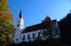 Catholic parish church St. Nicholas | ||
| ||
 Binswangen Location of Binswangen within Dillingen district 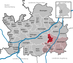 | ||
| Coordinates: 48°34′N 10°39′E / 48.567°N 10.650°ECoordinates: 48°34′N 10°39′E / 48.567°N 10.650°E | ||
| Country | Germany | |
| State | Bavaria | |
| Admin. region | Schwaben | |
| District | Dillingen | |
| Government | ||
| • Mayor | Anton Winkler (FW) | |
| Area | ||
| • Total | 11.91 km2 (4.60 sq mi) | |
| Elevation | 440 m (1,440 ft) | |
| Population (2017-12-31)[1] | ||
| • Total | 1,338 | |
| • Density | 110/km2 (290/sq mi) | |
| Time zone | CET/CEST (UTC+1/+2) | |
| Postal codes | 86637 | |
| Dialling codes | 08272 | |
| Vehicle registration | DLG | |
| Website | www.binswangen.de | |

Binswangen is a municipality in the district of Dillingen in Bavaria in Germany. The town is a member of the municipal association Wertingen.
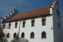
Binswangen synagogue
The town's 1836 synagogue, designed by Friedrich von Gärtner and notable as the first to use the horseshoe arch of Moorish architecture for windows and portals, was plundered in the Reichskristallnacht but not set ablaze because of its proximity to other buildings. It was restored beginning in 1987 and since 1996 has served as a community center, open to visitors on Sundays.[2][3] Other remnants of Binswangen's former Jewish community, which dates back to at least 1609, are the memorial site of the Jewish cemetery destroyed by the Nazis and the landmark Schilling House (ca. 1840).
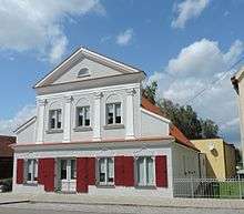
Schilling House
References
- ↑ "Fortschreibung des Bevölkerungsstandes". Bayerisches Landesamt für Statistik und Datenverarbeitung (in German). September 2018.
- ↑ "Archived copy". Archived from the original on 2011-07-18. Retrieved 2010-06-24.
- ↑ http://www.itcwebdesigns.com/tour_germany/dillingen_region.htm
| Authority control |
|---|
This article is issued from
Wikipedia.
The text is licensed under Creative Commons - Attribution - Sharealike.
Additional terms may apply for the media files.