Bimmah Sinkhole
Coordinates: 23°02′10″N 59°04′19″E / 23.03611°N 59.07194°E
.jpg)
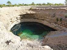
Bimmah Sinkhole (Arabic هـويـة نـجـم Hawaiyat Najm) is a water-filled depression, structurally a sinkhole, in the limestone of eastern Muscat Governorate in the Sultanate of Oman. A lake of turquoise waters, it is 50 m by 70 m wide and approximately 20 m deep. It is only about 600 m away from the sea,[1] between the coastal towns of Ḑibāb and Bimmah. The sinkhole was formed by a collapse of the surface layer due to dissolution of the underlying limestone.[2] However, locals believe that it was created by a meteorite, ‘Hawaiyat Najm’, which translates to ‘The Falling Star’ in Arabic, and hence the name.[3]
To preserve the sinkhole, the local municipality developed a park, Hawiyat Najm Park (Haweat Najm Park), around it, along with a stairway leading down to the lake.
Geology
The original cavern formed in the limestone of the Abat formation which lies below the more massive Seeb formation. When the cavern grew too large the rocks of the Seeb collapsed into it forming a sinkhole. It formed so close to the sea because of the increased subterranean water flow that occurred down-gradient.[2]
Notes and references
- ↑ "The world's most stunning sinkhole: Cavernous limestone bowl is so beautiful it's become a tourist attraction". Daily Mail. 16 May 2012.
- 1 2 Rajendran, Sankaran; Nasir, Sobhi (2014). "ASTER mapping of limestone formations and study of caves, springs and depressions in parts of Sultanate of Oman" (PDF). Environmental Earth Sciences. 71 (1): 133–146, figure 9d (page 142), page 144. doi:10.1007/s12665-013-2419-7.
- ↑ "Travel to Oman, Visit Muscat through Oman Travel Guide for Sultanate of Oman Adventure - Ministry of Tourism, Sultanate of Oman". www.omantourism.gov.om.
| Wikimedia Commons has media related to Hawiyat Najm. |