Big River (California)
| Big River | |
| Arroyo Grande | |
| river | |
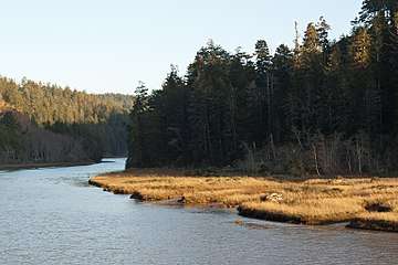 Big River, from the Big River Unit of Mendocino Headlands State Park. | |
| Country | United States |
|---|---|
| State | California |
| Region | Mendocino County |
| Source | Impassable Rocks |
| - location | 7 mi (11 km) south of Willits, California |
| - coordinates | 39°19′3″N 123°22′23″W / 39.31750°N 123.37306°W [1] |
| Mouth | Pacific Ocean |
| - location | Mendocino, California |
| - elevation | 0 ft (0 m) |
| - coordinates | 39°18′8″N 123°47′41″W / 39.30222°N 123.79472°WCoordinates: 39°18′8″N 123°47′41″W / 39.30222°N 123.79472°W [1] |
| Basin | 181 sq mi (469 km2) |

The Big River is a 41.7-mile-long (67.1 km)[2] river in Mendocino County, California, that flows from the northern California Coast Range to the Pacific Ocean at Mendocino, Mendocino County, California.
History
Pre-European contact the lands about the Big River belonged to the Me-tum’mah, or Mitom Pomo. This sub-tribe of the Northern Pomo lived in the area of Little Lake Valley near Willits and claimed the coast from south of the Noyo River at what is now Fort Bragg, to just north of the Navarro River, eighteen miles south.[3]
Big River is shown as Arroyo Grande on a diseño of the Albion Mexican land grant of October 30, 1844.[4]
The timber industry has dominated the area historically with logging of the lower basin starting about 1852, around the time that the first mill was constructed in what was then known as Mendocino City. The mill was sited on the bluffs and an apron chute to load finished wood onto ships was constructed at the mill.[5] Many dams were built on the river and their floodgates were opened every winter to sweep logs downstream to booms which kept the logs from floating out to sea.[6]
Watershed and Course
The Big River drains a 181 square miles (470 km2) watershed located in the northern California Coast Range culminating in the Big River estuary and entering the Pacific Ocean at the town of Mendocino, about 10 miles south of Fort Bragg.[5] The Big River watershed borders the watersheds of the Noyo River to the north, the Eel River and Russian River to the east, and the Little River, Albion River, and Navarro River to the south.
The river's headwaters are 30 miles (48 km) inland from the Pacific Ocean in the Mendocino Range, part of the California Coast Range. The headwater area of the river is fed by Montgomery Creek as it flows through the upland riparian habitat and virgin redwoods of Montgomery Woods State Reserve. From there, the river flows roughly west through Jackson Demonstration State Forest. The lower portions of the river pass through Mendocino Woodlands State Park and the Big River Unit of Mendocino Headlands State Park before reaching the mouth of the river at the Pacific Ocean just south of the town of Mendocino.
The Big River has an estuary at its mouth that provide habitat for a wide variety of organisms. It is a drowned river valley. Salt water from the ocean reaches 8.3 miles (13.4 km) upstream in the summer and 3 miles (5 km) in the winter, when flows are larger. The mouth, which closes in the summer on some rivers, stays open all year.[6]
Habitat and ecology
The Big River is fed by precipitation, 90 percent of which falls between October and April, and which averages 40 inches (1,000 mm) per year at Fort Bragg near the coast and 51 inches (1,300 mm) at Willits inland.[5] Winter weather is characterized by low intensity rain. The summers are dry and cool, with coastal fog. The river provides recreation and groundwater recharge for agricultural and industrial water supply for the community of Mendocino, California.[7]
The salmonid populations of coho salmon (Oncorhynchus kisutch), chinook salmon (Oncorhynchus tshawytscha), and steelhead trout (Oncorhynchus mykiss) in this watershed are all listed as endangered or threatened under the federal Endangered Species Act.[5] Other fish native to the river include the anadromous Pacific lamprey (Lampetra tridentata), sculpin (Cottus spp.), three-spined stickleback (Gasterosteus aculeatus), California roach (Lavina symmeticus), and the Sacramento sucker (Castomus occidentalis).[6]
The river provides wildlife habitat including cold freshwater habitat for fish migration and spawning.[7] California golden beaver (Castor canadensis subauratus) were restored to Big River in the early to mid-twentieth century despite extirpation in the California Fur Rush of the late eighteenth and early nineteenth centuries. A specimen was collected by J. G. Hall 10 miles (16 km) east of Mendocino on the Big River at elevation 200 feet (61 m) (precise location 39.31148, -123.6396) in 1966 for the California Academy of Sciences mammal collection.[8] Beaver ponds help restore salmonid habitat by capturing sediment and improving water quality, providing pools for juvenile salmonid over-summering, raising water tables which recharge streams in the dry season, increasing the area of aquatic and riparian habitat providing fish cover, and attenuating flashy storm flows.[9] A recent comprehensive literature review of the effects of beaver impoundments on fish illustrates that loss of beavers was directly related to significant population declines of now threatened or endangered California salmonids, including three species listed under the Endangered Species Act: Coho salmon (Oncorhynchus kisutch) (endangered), steelhead (Oncorhynchus mykiss) (threatened) and Chinook salmon (Oncorhynchus tshawytscha) (threatened).[10]
Other semi-aquatic mammals living in Big River include river otter (Lontra canadensis) and mink (Neovison vison).[6]
Land Use
Timber production is the primary land use in the area. The California Lumber Company built the first sawmill on the Mendocino County coast at the mouth of the river in 1852. By 1873, the name had changed to Mendocino Lumber Company and the mill was the most important in Mendocino County.[11] A railway line extended 9 miles (14 km) up the Big River to bring logs to the mill.[12] The mill operated until 1931, and was briefly reopened in 1938 to mill logs salvaged when a log raft broke up off the coast.[11] The North Fork Big River was logged by the Caspar Lumber Company. Logs were transported 35 miles (56 km) to the sawmill in Caspar from Camp 20 at California State Route 20 milepost MEN 17.3 by their Caspar, South Fork and Eastern Railroad. Caspar Lumber Company timberlands became Jackson Demonstration State Forest in 1955.[13] Jackson State Forest forms roughly a third of the area in the watershed, and land owned by the lumber companies Mendocino Redwood Company, Pioneer Resources, Hawthorne Timber Company and Weger Holdings make up most of the rest. As with most watersheds on the northern coast of California, the most significant ecological problem in the area is increased erosion caused by logging, leading to excessive sedimentation in the river and its tributaries.
See also
References
- 1 2 U.S. Geological Survey Geographic Names Information System: Big River
- ↑ U.S. Geological Survey. National Hydrography Dataset high-resolution flowline data. The National Map Archived 2012-04-05 at WebCite, accessed March 9, 2011
- ↑ Nicholas J. Santoro (2009). Atlas of the Indian Tribes of North America and the Clash of Cultures. iUniverse. pp. 226–. ISBN 978-1-4401-0795-5. Retrieved December 29, 2017.
- ↑ Erwin G. Gudde (2010). California Place Names: The Origin and Etymology of Current Geographical Names. University of California Press. pp. 35–. ISBN 978-0-520-26619-3.
- 1 2 3 4 Big River Total Maximum Daily Load for Sediment (PDF) (Report). U.S. Environmental Protection Agency. December 2001. Retrieved December 29, 2017.
- 1 2 3 4 Sheridan F. Warrick and Elizabeth D. Wilcox, eds. (1981). Big River - The Natural History of an Endangered Northern California Estuary. University of California Santa Cruz.
- 1 2 State of California Water Quality Control Plan North Coastal Basin 1B July 1975 p.13
- ↑ "Castor canadensis shastensis?". California Academy of Sciences. 1966-03-12. Archived from the original on 2011-07-21. Retrieved December 29, 2017.
- ↑ Peter Skidmore; et al. (April 2009). "Science Base and Tools for Evaluating Stream Engineering, Management, and Restoration Proposals" (PDF). NOAA Fisheries and U.S. Fish and Wildlife Service. p. 58. Retrieved Dec 19, 2009.
- ↑ Pollock, M. M.; M. Heim & D. Werner (2003). "Hydrologic and geomorphic effects of beaver dams and their influence on fishes". In S. Gregory; K. Boyer & A. Gurnell. The Ecology and Management of Wood in World Rivers (Symposium 37). American Fisheries Society. pp. 213–233. ISBN 1-888569-56-5.
- 1 2 Carranco, Lynwood (1982). Redwood Lumber Industry. Golden West Books. p. 204. ISBN 0-87095-084-3.
- ↑ Stindt, Fred A. (1978). The Northwestern Pacific Railroad: Redwood Empire Route (3rd ed.). Kelseyville, California: Fred A. Stindt. p. 44. ASIN: B0007F4A2M.
- ↑ Borden, Stanley T. (1966). Caspar Lumber Company. San Mateo, California: The Western Railroader.
Further reading
- Warrick, Sheridan F. and Elizabeth D. Wilson. Big River. The Natural History of an Endangered Northern California Estuary (Environmental Field Program Publication No. 6, 1981, University of California Santa Cruz)
External links
| Wikimedia Commons has media related to Big River (California). |