Białka Tatrzańska
| Białka Tatrzańska | |
|---|---|
| Village | |
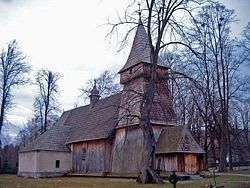 Wooden church | |
 Białka Tatrzańska | |
| Coordinates: 49°23′41″N 20°6′18″E / 49.39472°N 20.10500°E | |
| Country | 93.178.252.244:8080 |
| Voivodeship | Lesser Poland |
| County | Tatra |
| Gmina | Bukowina Tatrzańska |
| Highest elevation | 725 m (2,379 ft) |
| Lowest elevation | 650 m (2,130 ft) |
| Population | 2,200 |
| Website | http://www.bialka-tatrzanska.pl |
Bialka Tatrzanska [ˈbjau̯ka taˈtʂaɲska] is a village in the administrative district of Gmina Bukowina Tatrzańska, within Tatra County, Lesser Poland Voivodeship, in southern Poland, close to the border with Slovakia. It lies approximately 6 kilometres (4 mi) north of Bukowina Tatrzańska, 16 km (10 mi) north-east of Zakopane, and 75 km (47 mi) south of the regional capital Kraków.[1]
The village has a population of 2,200. A skiing center in the village attracts many tourists and has improved the economy of the area. Many residents have created chalets and bed and breakfast facilities to accommodate skiers.
External links
![]()
References
| Wikimedia Commons has media related to Białka Tatrzańska. |
| Seat |  | |
|---|---|---|
| Other villages | ||
Coordinates: 49°23′41″N 20°6′18″E / 49.39472°N 20.10500°E
This article is issued from
Wikipedia.
The text is licensed under Creative Commons - Attribution - Sharealike.
Additional terms may apply for the media files.