Bhamo
| Bhamo ဗန်းမော်မြို့ Hsinkai[1] | ||
|---|---|---|
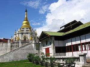 Pagoda Ike Kaw Daw (အိုက်ခေါတော် စေတီ) | ||
| ||
 Bhamo Location in Burma | ||
| Coordinates: 24°16′0″N 97°14′0″E / 24.26667°N 97.23333°E | ||
| Country |
| |
| Division |
| |
| District | Bhamo District | |
| Township | Bhamo Township | |
| Population (2005) | ||
| • Total | 47,920[2] | |
| • Ethnicities | Shan, Kachin, Chinese | |
| • Religions | Theravada Buddhism | |
| Time zone | UTC+6.30 (MST) | |
| Climate | Cwa | |

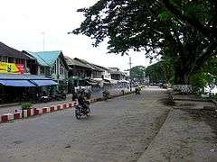
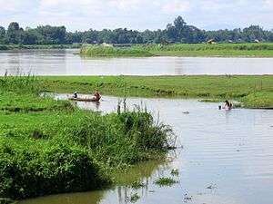
Bhamo (Burmese: ဗန်းမော်မြို့ ban: mau mrui., also spelt Banmaw) is a city of Kachin State in the northernmost part of Myanmar, located 186 km (116 mi) south from the capital city of the state of Kachin (Myitkyina). It is on the Ayeyarwady River. It lies within 65 km (40 mi) of the border with Yunnan Province, China.[3] The population consists of Chinese and Shan, with Kachin peoples in the hills around the town. It is the administrative center of Bhamo District and Bhamo Township.
Etymology
" Bhamo" derives from the Shan language term "Manmaw" (Shan: မၢၼ်ႈမေႃႇး; /maan3 mɔ3/), which means "potter's village."[4]
History

Bhamo was an important trading post with the Chinese Empire up to the nineteenth century, when copper coins from China flowed into Burma via Bhamo. VOC (United Dutch East India Company) records identified these copper coins as an important source of profit, and also mention the presence of a Customs Office in Bhamo to regulate the border trade.
From 1869 to 1879, it was the seat of British colonial Assistant political agent, subordinate to the Resident with the king of and in Ava. As of 1935, the town was situated at the highest navigable point of the river, and was the terminus of caravan routes from India and Burma, by which jade, in particular, was brought into China.
Bhamo was once called Sampanago, the capital of the now-extinct Shan predecessor kingdom of Wanmaw. The ruins of the old city walls, dating from the fifth Century, are found some 5 kilometres (3.1 mi) from the modern town.
Contemporary
A once weekly Myanma Airways flight is available, as are three times a week river ferries. It is the terminus of river ferries from Mandalay. There is no river ferry between Bhamo and state capital Myitkyina. The land route between Bhamo and Mu Se District (Muse, part of Northern Shan State), is in poor condition.
Bhamo is one of the official border trading towns between China and Myanmar.
Education
The town is home to Bhamo University. One can also study Engineering at Technological University(Bamaw), and computer and networking at Computer University(Bamaw).
Climate
Bhamo has a humid subtropical climate (Köppen climate classification Cwa). Temperatures are very warm throughout the year, although the winter months (December–February) are milder. There is a winter dry season (November–April) and a summer wet season (May–October).
| Climate data for Bhamo (1981–2010) | |||||||||||||
|---|---|---|---|---|---|---|---|---|---|---|---|---|---|
| Month | Jan | Feb | Mar | Apr | May | Jun | Jul | Aug | Sep | Oct | Nov | Dec | Year |
| Average high °C (°F) | 25.6 (78.1) |
28.1 (82.6) |
31.7 (89.1) |
34.0 (93.2) |
33.9 (93) |
32.3 (90.1) |
31.4 (88.5) |
31.7 (89.1) |
31.9 (89.4) |
30.9 (87.6) |
28.1 (82.6) |
25.5 (77.9) |
30.4 (86.7) |
| Average low °C (°F) | 10.1 (50.2) |
12.5 (54.5) |
16.0 (60.8) |
20.2 (68.4) |
23.1 (73.6) |
24.7 (76.5) |
24.8 (76.6) |
24.5 (76.1) |
23.8 (74.8) |
21.7 (71.1) |
16.5 (61.7) |
11.9 (53.4) |
19.2 (66.6) |
| Average rainfall mm (inches) | 5.4 (0.213) |
14.6 (0.575) |
15.0 (0.591) |
52.6 (2.071) |
177.1 (6.972) |
344.6 (13.567) |
406.0 (15.984) |
411.8 (16.213) |
217.1 (8.547) |
129.0 (5.079) |
38.7 (1.524) |
7.3 (0.287) |
1,819.2 (71.622) |
| Source: Norwegian Meteorological Institute[5] | |||||||||||||
See also

References & Sources
- ↑ "An Introduction to the Toponymy of Burma" The Permanent Committee of Geographic Names (PCGN), United Kingdom, October 2007, page 12, accessed 18 April 2010
- ↑ "Archived copy". Archived from the original on 20 June 2015. Retrieved 20 June 2015.
- ↑ "Manmaw", Encyclopædia Britannica
- ↑ Tun, Than (1988). "Observations on the Translation and Annotation of the Royal Orders Of Burma". Crossroads: An Interdisciplinary Journal of Southeast Asian Studies. 4 (1): 91–99.
- ↑ "Myanmar Climate Report" (PDF). Norwegian Meteorological Institute. pp. 26–36. Archived from the original (PDF) on 8 October 2018. Retrieved 8 October 2018.
- This article incorporates text from The Modern World Encyclopædia: Illustrated (1935); out of UK copyright as of 2005.
- This may be out of date or biased to the timeframe of that reference.
- WorldStatesmen - Burma/Myanmar
Further reading
| Wikisource has the text of the 1911 Encyclopædia Britannica article Bhamo. |
- 17th Century Burma and the Dutch East Indies Company 1634-1680, by Wil O. Dijk, NIAS Press
Coordinates: 24°16′N 97°14′E / 24.267°N 97.233°E
| Wikimedia Commons has media related to Bhamo. |
Capital: Myitkyina | ||
| Bhamo District |   | |
| Mohnyin District | ||
| Myitkyina District | ||
| Putao District | ||
| Main cities and towns | ||